|
|
| Car Park |
NO |
52397 |
98022 |
|
Park on road near the Boat Inn - cross bridge |
| Bridge |
NO |
52522 |
97722 |
.37k |
Over bridge and turn right |
| Fungle |
NO |
52407 |
97697 |
.12k |
Along road a short distance and go up footpath signposted Fungle |
| House |
NO |
52017 |
95527 |
2.36k |
Up hill following Fungle route. Keep straight on at house |
| Junction |
NO |
51702 |
93682 |
1.88k |
Footpath joins landy - follow landy uphill |
| Junction |
NO |
51422 |
92597 |
1.2k |
At junction turn left and head to summit |
| Carn Ferg |
NO |
52237 |
93352 |
1.15k |
From summit go NW over rough ground to gain outward route |
| Junction |
NO |
51702 |
93682 |
.63k |
Joins outward route at landy/footpath junction - return to car |
| |
|
|
|
|
Return back the way you came in |
| |
|
|
|
|
|
|
|
|
| Car Park |
NO |
46677 |
99112 |
|
Park car on parking area beside Cairngorm Park sign and walk east along road |
| Junction |
NO |
46887 |
99097 |
.22k |
At St.James junction turn left up road |
| Continue |
NO |
46517 |
99557 |
.59k |
Follow road north in open countryside |
| Junction |
NO |
46452 |
99892 |
.34k |
At junction keep straight on |
| Junction |
NJ |
46507 |
00017 |
.14k |
At junction keep straight on |
| Turn |
NJ |
46507 |
00342 |
.36k |
Turn right off track and make your way through gorse to summit of Mullach |
| Summit |
NJ |
46967 |
00562 |
.43k |
At summit head east along broad ridge to gate and cross |
| Gate |
NJ |
47287 |
00637 |
.33k |
Rough position of gate - cross and go to top of small wooded hill ahead |
| Hilltop |
NJ |
47637 |
00847 |
.42k |
At hilltop go down north and follow fence to gain access to field |
| Gate |
NJ |
47702 |
00997 |
.16k |
Gate into field - follow side of ditch east to corner of field |
| Junction |
NJ |
48027 |
00937 |
.33k |
At end of ditch rough track joined - turn left and go through gates & up hill |
| Junction |
NJ |
48042 |
01042 |
.11k |
At T junction turn right along rough track east to Long Cairn |
| Long Cairn |
NJ |
49082 |
00592 |
1.3k |
At Long Cairn retrace steps to a gate leading to a field sloping downhill |
| Gate |
NJ |
48657 |
00662 |
.43k |
Cross gate and walk down edge of field to gain gate at foot leading to landy |
| Farm Road |
NJ |
48227 |
00467 |
.49k |
Through gate and turn left along farm road to bridge over stream |
| Bridge |
NJ |
48207 |
00037 |
.5k |
Turn right and go over bridge and make way uphill in woodland crossing fence |
| Hilltop |
NO |
47382 |
99682 |
.92k |
Open hilltop - go down SW side to fence - cross turn right make way to track |
| Landy |
NO |
46517 |
99557 |
.89k |
Joining of outward route - turn left back to car |
|
|
|
| Car Park |
NO |
67897 |
44197 |
|
Park car at small area near bus stop |
| Track |
NO |
67827 |
44127 |
.10k |
Turn left on the track towards a house |
| House |
NO |
68137 |
44002 |
.34k |
turn right onto a path beside the house |
| Junction |
NO |
67672 |
43567 |
.76k |
Keep following the coastal path |
| Beach |
NO |
67047 |
42782 |
1.67k |
Either keep on the coastal path or go onto the beach to rejoin path at other end |
| Beach |
NO |
66897 |
42232 |
.59k |
Path rejoining |
| Victoria Park |
NO |
65837 |
41152 |
1.95k |
End of coastal path at Victoria park |
| Beach |
NO |
66897 |
42232 |
1.95k |
Return route |
| Beach |
NO |
67047 |
42782 |
.59k |
Return route |
| Junction |
NO |
67672 |
43567 |
1.67k |
Return route |
| House |
NO |
68137 |
44002 |
.76k |
Return route |
| Track |
NO |
67827 |
44127 |
.34k |
Return route |
| Car Park |
NO |
67897 |
44197 |
.10k |
Back to car |
|
|
|
| Car Park |
NO |
83312 |
72327 |
|
Park car at official car park and continue south on old line |
| Gourdon |
NO |
82502 |
70782 |
2.07k |
Gourdon Harbour - male for continuation of track south |
| Johnshaven |
NO |
79602 |
66977 |
4.99k |
Johnshaven Harbour - continue south through village |
| Headland |
NO |
78557 |
66352 |
1.23k |
Headland at a small hillock beside path. Picnic spot for views return by outward route.Note:- A footpath (part of the Coastal Path) continues on to Seagreens. Tangleha and St. Cyrus. This path is only suitable for walking."St. Cyrus is 3.81k further on from Headland,so the whole trip could be done" as a walk using two cars |
|
|
|
| Car Park |
NO |
34632 |
93532 |
|
Park off the road at an obvious parking area. Keep access for lorries free. |
| Junction |
NO |
34467 |
93462 |
.18k |
Turn left at junction. |
| Track Fork |
NO |
34442 |
92477 |
1.13k |
"At track fork,take the right fork heading uphill" |
| Junction |
NO |
33917 |
90927 |
1.75k |
"At junction,turn right slightly heading uphill" |
| Junction |
NO |
33742 |
90807 |
.21k |
"At junction,turn right almost doubling back" |
| Track Fork |
NO |
33757 |
91112 |
.31k |
Take left fork heading uphill |
| Faint Landy |
NO |
32992 |
91887 |
1.2k |
"At top of hill,take fainter landy heading left" |
| Moorland |
NO |
32737 |
91837 |
.28k |
On leaving wood turn left following path to Coyles summit |
| Coyles |
NO |
32967 |
91152 |
.85k |
Summit of Coyles of Muick. Retrace steps to exit of wood |
| Moorland |
NO |
32737 |
91837 |
.85k |
Exit of woodland. Turn left and make for Meall Dubh |
| Meall Dubh |
NO |
32487 |
91982 |
.34k |
Meall Dubh summit. On leaving summit retrace steps to wood. |
| Moorland |
NO |
32737 |
91837 |
.34k |
Reverse of above |
| Faint Landy |
NO |
32992 |
91887 |
.28k |
Reverse of earlier track |
| Loinmuie |
NO |
33232 |
91992 |
.28k |
Summit of Craig of Loinmuie. Head afterwards down grassy east slope |
| Landy |
NO |
33647 |
92182 |
.49k |
Join Landy Track. Turn left. |
| Junction |
NO |
33247 |
92777 |
1.57k |
Track junction. Turn left before gate |
| Track |
NO |
33387 |
93157 |
.41k |
Keep to the right track |
| Junction |
NO |
34162 |
93632 |
1.13k |
At junction turn right |
| Junction |
NO |
34167 |
93362 |
.27k |
At T junction turn left back to car |
| Junction |
NO |
34467 |
93462 |
.32k |
Keep going downhill |
| Car Park |
NO |
34632 |
93532 |
.18k |
Car park |
|
|
|
| Car Park |
NO |
30157 |
95522 |
|
Park off the road. Cross at the second gate (westerly one) - follow track along wall |
| Faint Path |
NO |
29382 |
95102 |
.91k |
At this point crab uphill following faint track |
| Junction |
NO |
29452 |
94557 |
.6k |
A more marked track is joined. Continue uphill |
| Summit |
NO |
29902 |
94652 |
.67k |
Summit of Craig nam Ban (last witch on Deeside burnt here) - follow ridge SE |
| Cairn |
NO |
29947 |
93807 |
.86k |
Duchess of Kents cairn. Continue along ridge |
| Cairn |
NO |
30287 |
93297 |
.62k |
Final cairn. Head SW over moorland to gain landy track |
| Landy |
NO |
30162 |
92167 |
1.15k |
Land Rover track joined. Turn left |
| Junction |
NO |
30977 |
91962 |
1.08k |
Straight on |
| Junction |
NO |
31007 |
92122 |
.16k |
Straight on |
| Junction |
NO |
31017 |
92347 |
.23k |
Junction - keep straight on track to right |
| Junction |
NO |
31452 |
93122 |
.92k |
Straight on |
| Fence |
NO |
32047 |
95332 |
2.44k |
Find a safe way to cross fence to gain rough landy track heading west |
| Woods |
NO |
30427 |
95622 |
2.17k |
Gain sparse woodland. Here turn west to gain initial crossing gate |
| Car Park |
NO |
30157 |
95522 |
.29k |
Cross gate back to car. |
|
|
|
| Car Park |
NO |
45917 |
98777 |
|
Car park at Dinnet cross roads. Cross road to gain old railway and head west |
| Bridge |
NO |
42132 |
97652 |
4.46k |
Cambus O May Suspension bridge. Go in front of cottage and follow path signs |
| Tea Room |
NO |
40642 |
98027 |
1.7k |
"If desired,detour into forest area,or tea room stop. Back to railway line" |
| Main Road |
NO |
38417 |
97202 |
2.4k |
Cross main road looking out for traffic |
| Bridge |
NO |
37257 |
95587 |
2.37k |
In Ballater make your way to Dee Bridge and turn right on South Road |
| Junction |
NO |
36657 |
94782 |
1.14k |
Turn right ignoring Glen Muick road. |
| Landy |
NO |
36012 |
94947 |
.69k |
Turn right onto landy track. Continue |
| Bridge |
NO |
34387 |
96512 |
2.47k |
Cross over suspension bridge and up to main road |
| Main Road |
NO |
34332 |
96862 |
.43k |
Up to main road. At main road turn right. Take care going along road |
| Fork |
NO |
35607 |
96947 |
1.37k |
"At road fork,turn left through Pass of Ballater" |
| Fork |
NO |
38462 |
97372 |
2.97k |
"At junction of main road,turn right" |
| Crossing |
NO |
38417 |
97202 |
.18k |
At this point turn left and return to car park by reverse of outward route |
| Tea Room |
NO |
40642 |
98027 |
2.4k |
"If desired,detour into forest area,or tea room stop. Back to railway line" |
| Bridge |
NO |
42132 |
97652 |
1.7k |
Cambus O May Suspension bridge. |
| Car Park |
NO |
45917 |
98777 |
4.46k |
Car park at Dinnet cross roads. Victoria Tea Room a good stop |
|
|
|
| Car Park |
NO |
31002 |
85192 |
|
Park at official car park and walk towards loch |
| Junction |
NO |
30467 |
84622 |
.79k |
Junction - keep straight on |
| Footpath |
NO |
30362 |
84162 |
.48k |
Turn right on footpath along north shore of loch |
| Boathouse |
NO |
29487 |
84492 |
1.07k |
At landy turn left and go along track |
| Footpath |
NO |
27852 |
82662 |
2.56k |
Turn right on footpath and skirt round lodge |
| Junction |
NO |
27067 |
82267 |
1k |
Having skirted lodge you return to path - turn left along shore path at junction |
| Junction |
NO |
27367 |
81827 |
.65k |
At junction turn right and head up steep footpath SW |
| Landy |
NO |
25932 |
80812 |
1.84k |
At top of hill join landy and turn left going along top of cliffs |
| Junction |
NO |
28842 |
82182 |
3.6k |
At junction keep NE on landy |
| Footpath |
NO |
30362 |
84162 |
2.56k |
Return along landy to where you went on outward route |
| |
|
|
|
|
Return back to car via outward route |
|
|
|
| Car Park |
NJ |
33492 |
00112 |
|
Park car at a convenient spot and walk up road |
| Gate |
NJ |
33607 |
00317 |
.25k |
Go through gate and up landy straight ahead - ignore branches to right |
| Lodge |
NJ |
33882 |
02982 |
3.14k |
"Up track north from Lodge,round hill and down to stream" |
| Stream |
NJ |
32472 |
04192 |
2.54k |
Continue downhill SW |
| Fenzie |
NJ |
31552 |
02872 |
1.72 |
"Down to Glen Fenzie,ignore junction to left and go through gate" |
| Main Road |
NJ |
31342 |
02917 |
.22k |
Down track to main road and turn left |
| Landy |
NJ |
31037 |
02242 |
.79k |
At landy - turn left onto it and follow downhill |
| Junction |
NJ |
31432 |
01152 |
1.17k |
At junction straight on |
| Junction |
NJ |
31607 |
00877 |
.33k |
At junction turn right downhill |
| Junction |
NJ |
31622 |
00542 |
2.48k |
At junction turn keep left following track past farm and house |
| Junction |
NJ |
33607 |
00317 |
.25k |
Turn right back to car |
|
|
|
| Car Park |
NO |
34037 |
95197 |
|
Park car at obvious area just off road and head uphill |
| Landy |
NO |
34382 |
94982 |
.44k |
Go down landy to the right to tarmac road |
| Tarmac |
NO |
35007 |
94157 |
1.15k |
At road turn right and go up road |
| Junction |
NO |
34942 |
92847 |
1.53k |
Road comes in from left - keep straight on up landy |
| Falls |
NO |
33202 |
89552 |
3.89k |
Falls of Muick - pause before continuing up main landy |
| Inchnabobart |
NO |
31112 |
87602 |
2.96k |
Up main landy to Inchnabobart junction - turn right |
| Junction |
NO |
29027 |
92197 |
6.28k |
Keep up landy to junction and turn right east |
| Main Road |
NO |
32502 |
95752 |
6.67k |
"Continue down main landy,over stile to main road - turn right" |
| Car Park |
NO |
34037 |
95197 |
1.78k |
Continue along road east back to car |
|
|
|
| Car Park |
NO |
64777 |
84447 |
|
Park off road. Cross road and go down landy |
| Junction |
NO |
64502 |
84352 |
.29k |
Once through gate - turn left at T junction |
| Junction |
NO |
61972 |
83527 |
3.11k |
At T junction turn left |
| Charr |
NO |
61552 |
83132 |
.62k |
At Charr Crossroads keep straight on |
| Junction |
NO |
58812 |
83367 |
3.17k |
At Junction turn right |
| Path |
NO |
58007 |
84372 |
1.38k |
Ignore footpath going off to the left |
| Junction |
NO |
57372 |
85287 |
1.2k |
At T Junction turn right along ridge |
| Junction |
NO |
59332 |
85902 |
2.37k |
Straight on |
| Junction |
NO |
60402 |
85972 |
1.15k |
Leave bike here and hike across rougher ground to Clachnaben and return |
| Clachnaben |
NO |
61422 |
86567 |
1.22k |
Rough track to summit and return to bikes |
| Junction |
NO |
60402 |
85972 |
1.22k |
Back to bikes and turn left down landy to Charr |
| Charr |
NO |
61552 |
83132 |
3.83k |
Rough track down to Charr. Turn left at Cross roads |
| |
|
|
|
|
Return back the way you came in |
| |
|
|
|
|
|
|
|
|
| Car Park |
NO |
76117 |
91542 |
|
First car park at Spyhill Forest car park and head SW |
| Junction |
NO |
75112 |
90482 |
1.58k |
At junction turn left south uphill |
| Junction |
NO |
74092 |
88952 |
2.07k |
At junction keep right |
| Junction |
NO |
72187 |
87702 |
2.53k |
Turn left uphill |
| Junction |
NO |
70952 |
88357 |
1.53k |
Turn right down landy |
| Junction |
NO |
70702 |
88867 |
.58k |
Turn left and head up landy up Kerloch |
| Footpath |
NO |
67322 |
87277 |
4.81k |
Turn left down rough footpath - BUMPY |
| Junction |
NO |
67017 |
89172 |
2.78k |
Straight on at junction |
| Junction |
NO |
67047 |
89277 |
.11k |
Take left fork |
| Car Park |
NO |
66272 |
90967 |
2.37k |
Down landy back to second car park |
| |
|
|
|
|
Return back the way you came in |
| |
|
|
|
|
|
|
|
|
| Car Park |
NJ |
64692 |
04602 |
|
Park car 1 at small quarry north of Torphins and drive with second car to east park |
| Car Park |
NJ |
74302 |
03882 |
|
Park car 2 at obvious parking area. Cross road and enter woods joining a path |
| Landy |
NJ |
74127 |
03882 |
.18k |
At landy turn right and follow |
| Crossroads |
NJ |
73447 |
04067 |
.72k |
At crossroads turn left and follow uphill |
| Junction |
NJ |
72692 |
03577 |
.94k |
At junction ignore and keep straight on |
| Junction |
NJ |
71952 |
03517 |
.79k |
At junction ignore and keep straight on |
| Junction |
NJ |
71827 |
03597 |
.15k |
At junction ignore and keep straight on |
| Junction |
NJ |
69972 |
03267 |
2k |
At junction ignore and keep straight on |
| Junction |
NJ |
67712 |
01842 |
2.88k |
At junction turn right |
| Turn |
NJ |
66817 |
03287 |
2.11k |
At this point turn NW and go down hill over open ground to join track |
| Landy |
NJ |
65807 |
03627 |
1.07k |
At this point a gate enters a landy through woodland - follow |
| Car Park |
NJ |
64692 |
04602 |
1.51k |
Car is reached at small quarry |
| |
|
|
|
|
|
|
|
|
| Car Park |
NO |
53212 |
90607 |
|
Park car at church |
| Farm |
NO |
52437 |
90457 |
.82k |
At farm take path down south side through gate |
| Footbridge |
NO |
52912 |
90297 |
.32k |
Follow muddy track to bridge and cross |
| Junction |
NO |
52072 |
89997 |
.33k |
At path junction keep straight on |
| Junction |
NO |
49932 |
85262 |
5.36k |
Look for marker posts showing path route before landy. At junction - right uphill |
| Tampie |
NO |
49687 |
86777 |
1.73k |
Summit of Tampie - continue on landy |
| Well |
NO |
49387 |
88052 |
1.34k |
St Colms Well - investigate then east to summit of Gannoch |
| Gannoch |
NO |
49672 |
88017 |
.29k |
Gannoch Summit. - head for landy |
| Landy |
NO |
50047 |
88277 |
.46k |
Start of landy track downhill NE |
| Junction |
NO |
50672 |
90002 |
2.17k |
At junction turn right downhill |
| Cross Roads |
NO |
51657 |
90512 |
1.17k |
At cross road - turn right onto footpath |
| Junction |
NO |
52072 |
89997 |
.87k |
Meet with outward track - turn left back to car via outward route |
|
|
|
| Car Park |
NO |
07922 |
89572 |
|
Park car off the road and walk back east |
| Landy |
NO |
08582 |
89137 |
.81k |
Just before bridge turn right and go up landy |
| Junction |
NO |
07297 |
87102 |
2.6k |
A footpath goes off to the left - IGNORE |
| Landy End |
NO |
03567 |
86257 |
3.94 |
End of Landy Track. Make for grave over moorland |
| Grave |
NO |
03437 |
86107 |
02k |
Sgt.Davies Grave. Was murdered here long ago. Head for Carn Liath |
| Carn Liath |
NO |
03557 |
86717 |
.64k |
Follow rough landy to summit then continue along ridge east |
| Sub Top |
NO |
05207 |
87417 |
.98k |
Along rough landy ridge |
| Summit |
NO |
06102 |
87777 |
.98k |
Carn na Moine summit. Continue on landy and rough peaty track |
| Landy start |
NO |
07687 |
88237 |
1.98k |
Join firm landy and go down track to main road |
| Car Park |
NO |
07922 |
89572 |
2.24k |
At main road turn left for car |
|
|
|
| Car Park |
NO |
15537 |
88172 |
|
Park car at obvious car park and walk up landy |
| Junction |
NO |
16202 |
87182 |
1.6k |
At junction turn right up zig zag landy to gain ridge and head south |
| Ridge |
NO |
15647 |
87212 |
.91k |
At ridge head south along ridge |
| Sron |
NO |
15542 |
85492 |
1.74k |
Sron nan Gabhar continue along ridge south |
| Summit |
NO |
15442 |
84107 |
1.63k |
Creag nam Gabhar summit - head east downhill to spur |
| Spur |
NO |
16282 |
83787 |
.91k |
Spurr continue down to join landy |
| Landy |
NO |
16997 |
83607 |
.74k |
Join landy turn left |
| Path |
NO |
17097 |
93767 |
.19k |
Turn right at this point down faint path to lodge |
| Bridge |
NO |
17722 |
84367 |
.96k |
Cross bridge and turn left down landy |
| Junction |
NO |
16647 |
85362 |
1.52k |
Keep down Glen Callater on Landy |
| Junction |
NO |
16202 |
87182 |
1.97k |
Join outward route - continue down landy to car |
|
|
|
| Car Park |
NO |
08882 |
89207 |
|
Park car at obvious car parking area - cycle up track to south |
| Bridge |
NO |
08657 |
88332 |
.93k |
Bridge reached - continue up landy |
| Detour |
NO |
08607 |
87072 |
1.34k |
At this point detour to visit Colonels Bed then back to Landy and continue |
| Bridge |
NO |
10047 |
84967 |
2.79k |
At bridge continue up landy |
| Bridge |
NO |
08867 |
82967 |
2.69k |
Continue up Landy |
| Altanour |
NO |
08262 |
82357 |
.88k |
End of landy at ruins of Altanour Lodge. |
|
|
|
| Car Park |
NO |
15127 |
91392 |
|
Park car at Braemar and catch 9.57am bus to Invercauld |
| Bus Stop |
NO |
18632 |
91087 |
|
Cross road to Auld Brig of Dee - go over and bear left |
| Junction |
NO |
18757 |
90682 |
.49k |
At junction turn right and follow landy uphill |
| Hut |
NO |
19047 |
88877 |
2.88k |
"At hut go to right of pond,cross slatted footbridge and go up glen to Loch Phadruig" |
| Phadruig |
NO |
17702 |
86207 |
3.04k |
Skirt north shore and descend west to bridge in Glen Callater |
| Bridge |
NO |
16352 |
86242 |
1.39k |
Down Glen Callater on landy to main road |
| Main Road |
NO |
15567 |
88217 |
2.6k |
At main road turn left for footbridge over the Clunie |
| Footbridge |
NO |
15382 |
88227 |
.25k |
Cross footbridge and head up to tarmac road |
| Road |
NO |
15222 |
88247 |
.17k |
Tarmac road - turn right and head along it back to Braemar |
| Car Park |
NO |
18837 |
91272 |
3.38k |
Back to car |
|
|
|
| Car Park |
NO |
18837 |
91272 |
|
Park car at Keilloch and catch bus for Crathie at road end 9.57am |
| Crathie stop |
NO |
26337 |
94992 |
|
Bus Stop. Cross road and walk along South Deeside Road |
| Junction |
NO |
26527 |
94222 |
1.04k |
At road junction turn right up road sign posted Distillery |
| Junction |
NO |
26507 |
94147 |
.08k |
At Junction turn right over stream and immediately left. Continue up landy |
| Junction |
NO |
25567 |
93507 |
1.19k |
Walk up landy through gorge to junction. Turn left. |
| Junction |
NO |
25827 |
90852 |
2.78k |
At junction turn right. You are on open moorland |
| Junction |
NO |
25497 |
90652 |
.41k |
At junction turn right on landy heading SW |
| Hut |
NO |
23757 |
90317 |
2.06k |
At this point take footpath to left heading SW |
| Junction |
NO |
22977 |
89662 |
1.09k |
Keep on the main path heading west |
| Junction |
NO |
21752 |
89952 |
1.37k |
Take left path heading SW |
| Junction |
NO |
20942 |
89352 |
1.14k |
Turn here heading west |
| Landy |
NO |
20167 |
89257 |
.9k |
At landy track turn right downhill |
| Junction |
NO |
19742 |
89587 |
.56k |
At landy junction turn left uphill |
| Hut |
NO |
19032 |
88887 |
1.18k |
At hut take landy track heading uphill behind hut NW |
| Junction |
NO |
18737 |
90672 |
2.83k |
At this point turn left to bridge |
| Auld Brig |
NO |
18607 |
90967 |
.34k |
Cross Auld Brig of Dee and turn right along to car park |
| Car Park |
NO |
18837 |
91272 |
.45k |
Back to car |
|
|
|
| Duthie Park |
NJ |
93862 |
04597 |
|
Park at Duthie Park car park and go up path onto old railway line |
| Culter Station |
NJ |
84107 |
00412 |
10.7k |
Follow old railway to Culter Station |
| Path Start |
NJ |
83987 |
00382 |
.14k |
"West on street,then left and immediately right up path to railway line" |
| Barbed Wire |
NO |
82832 |
99892 |
1.26k |
Along railway line to reach barbed wire fence - turn right up to minor road |
| Road |
NO |
82782 |
99982 |
.10k |
At minor road turn left along it |
| Juntion |
NO |
82312 |
99827 |
.50k |
Along road to reach Coalford Fork. Turn left along minor road |
| Crossroad |
NO |
80932 |
98852 |
1.72k |
Continue along road and keep straight on at cross road |
| Fork |
NO |
80777 |
98777 |
.17k |
Fork right following sign for path |
| Footpath |
NO |
80622 |
98792 |
.16k |
Blazed footpath starts - take it |
| Fork |
NO |
79722 |
98812 |
1.08k |
Follow footpath to fork - turn left |
| Minor Road |
NO |
79467 |
98312 |
.61k |
Continue on blazed path past pond and playing field to reach minor road - then right |
| Main Road |
NO |
79192 |
98832 |
.59k |
Up minor road to Drumoak village - turn left |
| Footpath |
NO |
78842 |
98627 |
.25k |
Along main road to footpath on left - take it and follow the railway line |
| Turn |
NO |
75142 |
96487 |
2.71k |
Path turns right to join North Deeside Road |
| Main Road |
NO |
75102 |
96597 |
.12k |
Main road - turn left along it |
| Slug Road |
NO |
74937 |
96537 |
.11k |
At Cross Road turn left down Slug Road |
| Blazed Rd |
NO |
75037 |
96322 |
.15k |
Turn right on blazed road past houses and sand quarry to old pack horse bridge |
| Pack Horse |
NO |
74337 |
96212 |
.44k |
Go off blazed track and over old pack horse bridge then follow new path |
| Milton Stn |
NO |
74087 |
96207 |
.16k |
At Milton Railway go along path to the south of the carriages |
| Supermarket |
NO |
71097 |
95902 |
2.00k |
At back of Supermarket go along tarred footpath to railway bridge - head west |
| Car Park |
NO |
69807 |
95512 |
.86k |
Bellfield Car Park |
|
|
|
| Car Park |
NO |
26802 |
98762 |
|
Park 1st car on old military road close to a cairn |
| Junction |
NO |
27762 |
97512 |
2.20k |
From car ascend up the landy track to a junction |
| Junction |
NO |
29492 |
98352 |
2.03k |
Junction of track - continue east |
| Geallaig |
NO |
29802 |
98162 |
.36k |
Geallaig summit - continue east on landy |
| Sub top |
NO |
30987 |
98022 |
1.25k |
Sub top - continue east on landy |
| Sub top |
NO |
31947 |
98267 |
1.00k |
Sub top - continue east on landy |
| Bend |
NO |
32242 |
98342 |
.31k |
Track starts to turn NW - continue on this to car park at Gairn |
| Car Park |
NJ |
31947 |
247 |
2.62k |
Park for 2nd car |
|
|
|
| Car Park |
NO |
35562 |
96957 |
|
Park car in lay by on main Braemar road near Pass of Ballater |
| Pass |
NO |
35812 |
96967 |
.25k |
Walk down Pass of Ballater to private road |
| Gate |
NO |
36432 |
97017 |
.64k |
Continue down Pass of Ballater road to a gate on the left |
| Wood |
NO |
36677 |
98472 |
1.60k |
Head north up the landy to north edge of wood |
| Junction |
NO |
36312 |
99562 |
1.26k |
Head up the landy over the brow of hill 547 to a junction |
| Junction |
NJ |
36127 |
237 |
.74k |
Keep on the main landy to another junction going east |
| Junction |
NJ |
36002 |
587 |
.38k |
Keep on the main landy to a junction heading west |
| Stream |
NO |
34927 |
99392 |
1.96k |
Go down Glen Bardy on the rough landy to a stream |
| Junction |
NO |
34787 |
98247 |
1.27k |
Cross stream and follow the landy to a junction |
| Burn |
NO |
35287 |
97822 |
.67k |
Keep on the landy into a field then a small burn |
| Abergairn |
NO |
35457 |
97397 |
.49k |
Follow the field track to Abergairn |
| Pass |
NO |
35812 |
96967 |
.59k |
Down the main Abergairn drive to Pass of Ballater |
| Car Park |
NO |
35562 |
96957 |
.25k |
Return back to the car |
|
|
|
| Car Park |
NO |
26542 |
94157 |
|
Park on road just of the Lochnagar Distillery Road at Easter Balmoral |
| Shop |
NO |
26447 |
94147 |
.10k |
Walk across road and turn left at shop - head up tarmac road |
| Gate |
NO |
26062 |
93797 |
.54k |
Go through gate then turn right through another gate and along path to junction |
| Junction |
NO |
25982 |
93882 |
.12k |
Turn left at junction and go up path beside gorge - cross bridge to junction |
| Junction |
NO |
25717 |
93747 |
.36k |
Turn right at larger path - after few yards head west up through woods to cairn |
| Cairn |
NO |
25632 |
93837 |
.19k |
Princess Helena's Cairn - back to footpath then left along it |
| Cairn |
NO |
25613 |
93824 |
.43k |
Princess Louise's Cairn - continue following footpath |
| Cairn |
NO |
25558 |
94350 |
.22k |
Purchase Cairn. Go down footpath to junction |
| Junction |
NO |
25517 |
94367 |
.11k |
Turn right at junction and follow path downhill to cairn |
| Cairn |
NO |
25529 |
94519 |
.20k |
Prince Leopold's Cairn - retrace steps back up path to junction |
| Junction |
NO |
25517 |
94367 |
.20k |
At junction keep straight on then go through clearing on right to cairn |
| Cairn |
NO |
25380 |
94295 |
.23k |
Prince Arthur's Cairn. Back to path and continue along footpath to junction |
| Junction |
NO |
25332 |
94107 |
.29k |
Turn right at junction and continue to next junction |
| Junction |
NO |
25097 |
94147 |
.27k |
Turn left at this junction uphill then downhill to cairn |
| Cairn |
NO |
24856 |
93726 |
.49k |
Princess Alice's Cairn. Continue down path to landy track |
| Landy |
NO |
24557 |
93527 |
.38k |
Turn left along landy then right over green footbridge over Geldie |
| Junction |
NO |
24552 |
93342 |
.25k |
Turn left over footbridge then left fork to clear picnic area beside Geldie |
| Picnic |
NO |
24682 |
93267 |
.30k |
Picnic Spot. Retrace steps over footbridge then right up landy to junction after gate |
| Junction |
NO |
25562 |
93502 |
1.44k |
At junction turn right up landy |
| Junction |
NO |
25567 |
93182 |
.33k |
Turn left at junction up footpath to cairn. |
| Cairn |
NO |
25963 |
93434 |
.75k |
Prince Albert's Cairn. Continue on footpath downhill to cairn |
| Cairn |
NO |
26290 |
93934 |
.66k |
"Princess Beatrice's Cairn. Continue on footpath downhill,through gate to road" |
| Shop |
NO |
26447 |
94147 |
.55k |
Return back to the car |
| Car Park |
NO |
26542 |
94157 |
.10k |
Car Park |
| |
|
|
|
|
|
|
|
|
| Car Park |
NO |
64777 |
84532 |
|
Park car at car parking area near Spittal of Glen Dye bridge |
| Junction |
NO |
61982 |
83547 |
3.48k |
Down track - over river and left along west bank of river on landy |
| Charr |
NO |
61547 |
83127 |
.65k |
Charr Bothy - south over bridge and up east bank of Water of Charr on landy |
| Hut |
NO |
61867 |
81047 |
2.33k |
Continue on the main landy |
| Fence |
NO |
61697 |
80562 |
.53k |
"At high fence,follow landy up along east side of fence on rough landy" |
| Gate |
NO |
61952 |
79972 |
.68k |
Go through gate and follow landy on west side of fence |
| Junction |
NO |
62437 |
79567 |
.64k |
Keep straight on at junction |
| Brow of hill |
NO |
62527 |
79427 |
.17k |
At fence on brow of hill go through the gate and descend rough landy |
| Gate |
NO |
63062 |
78867 |
.78k |
Go through the gate and continue on good landy track |
| Junction |
NO |
64252 |
78432 |
1.37k |
Turn right downhill towards woods |
| Junction |
NO |
64247 |
78247 |
.21k |
Turn left on landy going through small pass beside lochan - follow landy downhill |
| House |
NO |
66437 |
78222 |
2.75k |
Clattering Brig for second car park beside tearoom |
|
|
|
| Car Park |
NO |
15042 |
91357 |
|
Braemar Car Park - walk up Chapel Brae to duck pond and junction |
| Junction |
NO |
14137 |
90927 |
1.23k |
Turn up hill up the landy past a house to viewpoint |
| Viewpoint |
NO |
14262 |
90537 |
.47k |
Pause at the viewpoint then continue uphill |
| Path |
NO |
14402 |
90452 |
.16k |
Up a short distance to footpath heading for Morrone - head steeply up hill |
| Morrone |
NO |
13202 |
88647 |
2.36k |
Summit of Morrone - continue south along landy to sub top |
| Sub Top |
NO |
12857 |
87807 |
1.1k |
At sub top descend east down landy to minor road |
| Road |
NO |
15217 |
88202 |
3.06k |
"On reaching minor road,turn left and head back to Braemar" |
| Car Park |
NO |
145042 |
91357 |
3.35k |
Down road to Car Park |
|
|
|
| Bus Drop |
NO |
06212 |
62822 |
|
Leave bus or second car - cross road to start of signposted trail |
| Wood |
NO |
07012 |
64242 |
1.82k |
Edge of a wood - keep straight on |
| Fork |
NO |
07287 |
64422 |
.33k |
Track forks - take left hand signposted track - follow track through forest |
| Wood |
NO |
07772 |
65892 |
1.62k |
Edge of wood. Continue up the landy track |
| Hut |
NO |
08232 |
67352 |
1.59k |
Picnic hut reached. Continue up footpath (signposted) |
| Col |
NO |
09422 |
68372 |
1.65k |
Col reached - head downhill on the footpath |
| Hotel |
NO |
10987 |
69912 |
2.29k |
Spittal of Glenshee Hotel |
| |
|
|
|
|
|
|
|
|
| Car Park |
NO |
26102 |
98162 |
|
Park close to landy track - cycle down it |
| Junction |
NO |
25642 |
98757 |
.77k |
Keep downhill on main track |
| Junction |
NO |
25842 |
99782 |
1.1k |
Keep on downhill at junction |
| Junction |
NJ |
24832 |
00802 |
1.69k |
Straight on at junction |
| Junction |
NJ |
19312 |
02627 |
6.73k |
At this junction turn left to bridge |
| Bridge |
NJ |
19057 |
02032 |
.74k |
Cross bridge and turn right |
| Shoulder |
NO |
18582 |
98802 |
3.87k |
Shoulder of Cullardoch keep on landy |
| Junction |
NO |
17822 |
96277 |
2.95k |
Keep straight on at junction |
| Junction |
NO |
17847 |
94392 |
1.93k |
At junction keep left |
| Tarmac |
NO |
17602 |
92362 |
2.19k |
At tarmac road turn left |
| Car Park |
NO |
18822 |
91292 |
1.64k |
Keilloch Car Park. |
|
|
|
| Car Park |
NJ |
84162 |
00442 |
|
Park car at Culter railway station - walk down side of churchyard and downstream |
| Gate |
NJ |
85842 |
00417 |
2.06k |
Cross road and through gate to gain river bank - head downstream |
| Stile |
NJ |
88047 |
01562 |
3.1k |
Cross stile to field and over a wooden bridge - turn right back to River Dee |
| Shakkin |
NJ |
89732 |
02647 |
2.28k |
Walk past water works and along river bank |
| Woods |
NJ |
91247 |
02907 |
1.68k |
Continue along river bank |
| Sainsburys |
NJ |
92632 |
03237 |
1.49k |
Continue along bank and under road bridge |
| Car Park |
NJ |
92922 |
03857 |
.69k |
Second car park. Alternative is to continue to Duthie Park |
|
|
|
| Car Park |
NJ |
74012 |
5697 |
|
Park car opposite primary school and head west over cross roads |
| Track |
NJ |
73437 |
5667 |
.58k |
At signpost take path for Calton viewpoint up to farm |
| Farm |
NJ |
73382 |
5802 |
.15k |
Go left into field and go diagonally NW |
| Picnic Seat |
NJ |
73022 |
6152 |
.50k |
At picnic seat go over wall and through narrow wood then across field to track |
| Landy |
NJ |
72767 |
6557 |
.48k |
At landy track bear left along track to a gate |
| Gate |
NJ |
72617 |
6557 |
.18k |
Turn right NE a short distance up track to a path |
| Path |
NJ |
72742 |
6657 |
.16k |
at the path turn left and climb up the path north to Barmekan |
| Barmekan |
NJ |
72622 |
7122 |
.52k |
Barmekan Hill Fort - continue north |
| Junction |
NJ |
72852 |
7387 |
.48k |
Follow the footpath till it joins a landy track coming in from the right |
| Gate |
NJ |
72687 |
7957 |
.63k |
Gate at edge of wood go through on landy |
| Junction |
NJ |
72677 |
8027 |
.07k |
at Junction turn right and head east on landy |
| House |
NJ |
73122 |
8127 |
.52k |
Follow the farm track down to the main road |
| Main road |
NJ |
74127 |
8042 |
1.04k |
Cross the main road into Dunecht Estate |
| Junction |
NJ |
74557 |
7742 |
.63k |
Keep straight on at the junction |
| Junction |
NJ |
74642 |
7752 |
.09k |
Turn right at the junction near a small pond |
| Golf Course |
NJ |
74767 |
7612 |
.21k |
Continue straight on |
| Lodge |
NJ |
75172 |
7042 |
.76k |
At Lodge house on road turn right and follow to main road |
| Main road |
NJ |
73772 |
6267 |
1.77k |
"Main Echt road,turn left back to Village and car park" |
| Car Park |
NJ |
74012 |
5697 |
.75k |
Return to car |
|
|
|
| Car Park |
NO |
14142 |
77532 |
|
Cairnwell car park south end - head up landy east |
| Odhar |
NO |
15532 |
77372 |
1.56k |
Meall Odhar - continue towards Glas Maol |
| Glas Maol |
NO |
16697 |
76582 |
1.45k |
Glas Maol summit - head for Creag Leacach |
| Ridge |
NO |
16047 |
75872 |
.99k |
Grassy ridge - follow |
| Rocks |
NO |
16032 |
75252 |
.64k |
Rocky ridge walk to Creag Leacach |
| Leacach |
NO |
15467 |
74537 |
.91k |
Summit - follow path and wall |
| Sub Top |
NO |
14822 |
74142 |
.86k |
Keep following ridge south |
| Carn Ait |
NO |
14297 |
73417 |
.92k |
Carn Ait sub top - continue down ridge |
| Mhala |
NO |
13982 |
72572 |
.92k |
Continue down ridge |
| Sub Top |
NO |
13807 |
72042 |
.58k |
Continue down ridge |
| Climb |
NO |
13522 |
71752 |
.44k |
Start of final climb |
| Diamh |
NO |
13572 |
71252 |
.50k |
Carn an Diamh summit - head SW towards landy |
| Landy |
NO |
12442 |
70647 |
1.30k |
Landy joined - turn left downhill |
| Gate |
NO |
12112 |
70182 |
060k |
Gate - go through and follow Caterlan Trail sign |
| Main Road |
NO |
12112 |
70182 |
1.22k |
Main road - turn left to Spittal of Glenshee |
| Hotel |
NO |
10987 |
69912 |
.54k |
Spittal of Glenshee Hotel |
| |
|
|
|
|
|
|
|
|
| Car Park |
NJ |
58437 |
4297 |
|
Park Lumphanan Square or alight from 202 bus. At T junct turn right & slip onto path |
| Gate |
NJ |
58187 |
3897 |
.52k |
At gate on left of path - cross over road and head uphill |
| Junction |
NJ |
57902 |
3262 |
.77k |
Footpath meets tarmac road - continue SW |
| Bend |
NJ |
58097 |
2472 |
.81k |
Follow road round on tarmac road |
| Old Town |
NJ |
57762 |
2092 |
.57k |
At Old Town bear left down track at last house |
| Signpost |
NJ |
57837 |
1807 |
.39k |
"Followpath signpost direction near old barn up between walls,through gate and wood" |
| Signpost |
NJ |
57957 |
1437 |
.40k |
At edge of wood follow sign through gate and field |
| Signpost |
NJ |
57812 |
1292 |
.21k |
Follow signpost direction at wall and head south on wide path |
| Signpost |
NJ |
57807 |
987 |
.36k |
Follow signpost direction at wall and head south on wide path |
| Signpost |
NJ |
57762 |
922 |
.08k |
Through gate following signpost |
| Road |
NJ |
57627 |
732 |
.26k |
Reach road and turn left downhill following signposts |
| Signpost |
NJ |
57827 |
547 |
.28k |
Continue downhill on path following signpost to right of house |
| Signpost |
NJ |
58302 |
242 |
.57k |
Continue downhill on path following signpost |
| Main Road |
NO |
58962 |
99717 |
.87k |
Kincardine O Neil Village - turn left on south pavement to east end. |
| Signpost |
NO |
59522 |
99467 |
.62k |
At east end slip onto Deeside Way footpath |
| Road |
NO |
59802 |
99257 |
.36k |
At end path go along grass verge of main road |
| Path |
NO |
59962 |
98972 |
.37k |
Go down Deeside Way and follow |
| Potarch |
NO |
80827 |
97367 |
1.97k |
Up onto car park at Potarch Bridge. Alternative catch 201 bus |
|
|
|
| Car Park |
NJ |
45037 |
00082 |
|
Reserve car park - head west up road |
| Gate |
NO |
44767 |
99862 |
.35k |
Through gate onto rough farm track then down to lochside |
| Lochside |
NO |
44287 |
99717 |
.51k |
Lochside - follow footpath along shore |
| Landy |
NJ |
43907 |
00127 |
.87k |
Landy joined. turn left |
| Junction |
NJ |
43777 |
00282 |
.22k |
Footpath goes off left - take this and follow |
| Car Park |
NJ |
43362 |
00047 |
.53k |
Small Car Park - continue on footpath |
| Car Park |
NO |
42997 |
99742 |
.51k |
Burn o Vat Car Park - take footpath up the burn |
| Footbridge |
NO |
42577 |
99592 |
.48k |
"Turn right,cross bridge and up steps" |
| Junction |
NO |
42632 |
99722 |
.17k |
At footpath junction turn left |
| Landy |
NO |
41807 |
99867 |
.88k |
Path joins landy. Turn right and follow |
| Main Road |
NJ |
43457 |
00987 |
2.04k |
Down landy to road and turn right |
| Landy |
NJ |
43602 |
00582 |
.45k |
Turn left onto landy and follow |
| Junction |
NJ |
43777 |
00282 |
.22k |
At this point head left on a landy going between fields |
| Footpath |
NJ |
44837 |
00337 |
1.14k |
Follow landy to footpath off to right and take |
| Car Park |
NJ |
45037 |
00082 |
.69k |
Back to car |
|
|
|
| Car Park |
NJ |
59222 |
07262 |
|
"Park car in small quarry on B9119 - cross road,down landy through gate then left" |
| Wood |
NJ |
60127 |
08577 |
2.07k |
Having followed track uphill beside fence arrive at wood for a break |
| Summit |
NJ |
60637 |
08712 |
.54k |
Having followed landy uphill beside wall arrive at summit cairn |
| Wood |
NJ |
60127 |
08577 |
.54k |
Reverse outward route |
| Car Park |
NJ |
59222 |
07262 |
2.07k |
Car park |
|
|
|
| Bus Drop |
NJ |
24717 |
12882 |
|
Leave bus or second car - head west up ski track road |
| Sub Top |
NJ |
24077 |
12677 |
.82k |
Head up ski road |
| Chruinnich |
NJ |
23717 |
13217 |
.68k |
Summit of Beinn a'Chruinnich. Head west over rough ground |
| Turn |
NJ |
23067 |
12912 |
.75k |
Turn south towards Carn Ealasaig |
| Summit |
NJ |
22747 |
11777 |
1.19k |
Summit of Carn Ealasaig. Head to landy just west of summit |
| Wood |
NJ |
22337 |
09842 |
2.19k |
Down landy to reach wood |
| Junction |
NJ |
22702 |
09292 |
.68k |
Down track through wood to junction and turn left |
| Stream |
NJ |
22967 |
09467 |
.35k |
Cross stream and continue east along the landy |
| Stream |
NJ |
24717 |
09717 |
1.81k |
Cross stream and continue east along the landy |
| Road |
NJ |
25697 |
09172 |
1.23k |
Join main road - turn right downhill |
| Entrance |
NJ |
25702 |
09027 |
.16k |
Entrance to Castle Car Park - go down |
| Car Park |
NJ |
25412 |
8962 |
.30k |
Corgarff Castle Car Park |
| |
|
|
|
|
|
|
|
|
| Car Park |
NJ |
38097 |
09157 |
|
Park car just before forestry gate leaving access for vehicles |
| Junction |
NJ |
37497 |
08822 |
.7k |
Ignore junction and keep straight on |
| Junction |
NJ |
37007 |
08632 |
.53k |
Ignore junction and keep straight on |
| Junction |
NJ |
36587 |
08462 |
.46k |
Ignore junction and keep straight on |
| Junction |
NJ |
36042 |
08042 |
.72k |
Ignore junction and keep straight on |
| Fork |
NJ |
35752 |
08127 |
.32k |
At fork turn left uphill on rough landy |
| Junction |
NJ |
35432 |
07282 |
1.1k |
Keep left uphill |
| Junction |
NJ |
35467 |
06982 |
.32k |
Keep right on landy |
| Gate |
NJ |
35487 |
06242 |
.79k |
Go through gate and continue along ridge |
| Descent |
NJ |
34842 |
05622 |
.98k |
Along ridge to highest point then descend curving south and west to gully |
| Castle Wilson |
NJ |
34677 |
05677 |
.46k |
Down to cave - TAKE CARE - Investigate and return |
| |
|
|
|
|
Return back to the car the way you came |
| |
|
|
|
|
|
|
|
|
| Car Park |
NJ |
25397 |
08962 |
|
Park car at Castle Car Park |
| Road |
NJ |
24032 |
09232 |
1.45k |
Head west along tarmac private road |
| Junction |
NJ |
21737 |
08312 |
2.65k |
"Road becomes landy. At junction,keep straight on. Few yards detour to view lochan" |
| Junction |
NJ |
20987 |
08202 |
.77k |
Keep straight on |
| Junction |
NJ |
17967 |
08002 |
3.89k |
Inchrory Junction - turn left |
| Bridge |
NJ |
17882 |
07322 |
.73k |
At bridge turn right and head west - worth stopping to view waterfalls close by |
| Junction |
NJ |
15527 |
07007 |
2.86k |
Turn left at junction |
| Junction |
NJ |
15312 |
07127 |
.28k |
Turn left at junction |
| Hut |
NJ |
12617 |
05962 |
3.18k |
End of outward section - views here of Ben Avon. |
| |
|
|
|
|
Return back to the car the way you came |
| |
|
|
|
|
Note that the end of the landy track finshes at Faindouran Lodge MBA |
| |
|
|
|
|
another 5.25k further on. |
| |
|
|
|
|
|
|
|
|
| Car Park |
NJ |
41127 |
10867 |
|
"Park off road if able,otherwise good parking area up the hill" |
| Junction |
NJ |
38867 |
08732 |
3.4k |
Straight on. Look out for Helen Denerley sculptures across stream |
| Junction |
NJ |
38047 |
06452 |
2.65k |
Junction - cross stream and south up hill |
| Junction |
NJ |
38107 |
05777 |
.7k |
Keep on uphill at junction |
| Hut |
NJ |
38232 |
05372 |
.51k |
Hut. View Helen Denerley Eagle and return |
| Junction |
NJ |
38107 |
05777 |
.51k |
At junction turn right |
| Junction |
NJ |
38867 |
06212 |
.95k |
Continue along landy |
| Crossroad |
NJ |
39287 |
06267 |
.43k |
At crossroad turn right. Very rough track on descent |
| Landy |
NJ |
40262 |
06537 |
1.37k |
Cross over onto landy heading east on open ground |
| Junction |
NJ |
41162 |
07717 |
1.51k |
At junction turn right down through woodland |
| Main Road |
NJ |
42197 |
07477 |
1.19k |
Down through woodland to Main Road - turn left |
| Car Park |
NJ |
41127 |
10867 |
3.89k |
North along main road to car |
|
|
|
| Car Park |
NJ |
33592 |
15817 |
|
Park car at obvious parking area beside woods |
| Lost Gallery |
NJ |
31292 |
15852 |
2.39k |
Up landy through gateway to reach Lost Gallery |
| Duffdefiance |
NJ |
30382 |
16677 |
1.35k |
Follow landy beside woods - cross stream to Duffdefiance ruin |
| Junction |
NJ |
29622 |
17652 |
1.29k |
Up steep hill on landy track to junction - straight on |
| Junction |
NJ |
28692 |
18452 |
1.24k |
Keep on landy over Finlate Hill |
| Col |
NJ |
28072 |
19182 |
.98k |
Up footpath to obvious Col on Ladder Hills |
| Junction |
NJ |
28692 |
18452 |
.98k |
Return route |
| Junction |
NJ |
29622 |
17652 |
1.24k |
Return route |
| Junction |
NJ |
30382 |
16677 |
1.29k |
Duffdefiance Ruin - Return route |
| Fork |
NJ |
31292 |
15852 |
1.35k |
Lost Gallery - Return route |
| Car Park |
NJ |
33592 |
15817 |
2.39k |
Car Park |
| |
|
|
|
|
|
|
|
|
| Car Park |
NJ |
33292 |
10947 |
|
Park on grass verge just off the main road and walk up minor road |
| Tarmac |
NJ |
32717 |
11842 |
1.13k |
End of tramac road follow rougher track north west |
| Fork |
NJ |
31592 |
12417 |
1.31k |
Take left fork and follow the landy uphill |
| Shiel |
NJ |
27112 |
12892 |
4.89k |
Follow the track along the valley to reach Shiel |
| Summit |
NJ |
27912 |
14622 |
2.15k |
Right fork up steep hill to The Socach |
| Junction |
NJ |
28402 |
15162 |
.74k |
Down track from summit to T junction. Turn right |
| Junction |
NJ |
29777 |
14067 |
1.98k |
Go straight on to Lochan |
| Junction |
NJ |
29937 |
13992 |
.18k |
Hut beside lochan. Continue on track beside lochan |
| Fork |
NJ |
31592 |
12417 |
2.35k |
Joining of outward route |
| Tarmac |
NJ |
32717 |
11842 |
1.31k |
Tarmac road joined - back down to car |
| Car Park |
NJ |
33292 |
10947 |
1.13k |
Car park |
| |
|
|
|
|
|
|
|
|
| Car Park |
NJ |
33520 |
15785 |
|
Park car at obvious parking area - go to junction just before bridge |
| Junction |
NJ |
33420 |
15790 |
.1k |
do not cross bridge but turn right along good landy track |
| House |
NJ |
31260 |
15260 |
2.53k |
At house go through yard to gain other landy through field and follow up gorge |
| Junction |
NJ |
29820 |
14015 |
1.98k |
At junction just beyond rough hut turn left and follow |
| Junction |
NJ |
29885 |
13985 |
.16k |
Just before hut at loch turn left and follow track up hillside |
| Junction |
NJ |
33730 |
13750 |
4.13k |
Path joins landy - straight on for a short distance |
| Junction |
NJ |
33880 |
13690 |
.17k |
At foot of track turn left at T junction and follow |
| Junction |
NJ |
33420 |
15790 |
2.26k |
You are now back on outward route - return to car |
| Car Park |
NJ |
33520 |
15785 |
.19k |
Car park |
|
|
|
| Car Park |
NJ |
26172 |
08662 |
|
Park car keeping access to landy track clear |
| Junction |
NJ |
26292 |
08237 |
.45k |
At junction continue straight on |
| Bridge |
NJ |
27167 |
07562 |
1.16k |
General Wade bridge. Continue up landy |
| Bridge |
NJ |
28047 |
06937 |
1.23k |
Another General Wade bridge. Continue. |
| Fork |
NJ |
28314 |
06927 |
.28k |
"At fork,turn right" |
| Track Fork |
NJ |
28487 |
06782 |
.23k |
"At fork,turn right" |
| Summit |
NJ |
27092 |
06062 |
2.58k |
Summit of hill. |
| Moorland |
NJ |
26992 |
05437 |
.68k |
Rough faint track to this waypoint |
| Landy |
NJ |
26447 |
05147 |
.67k |
Follow track |
| Sub Top |
NJ |
25902 |
05947 |
1.14k |
Sub Top summit |
| Junction |
NJ |
25832 |
06907 |
1.15k |
Track comes in from right. Continue downhill |
| Junction |
NJ |
26292 |
08237 |
1.48k |
Joining of outward route. Turn left |
| Car Park |
NJ |
26172 |
08662 |
.45k |
Back to car |
|
|
|
| Car Park |
NJ |
67172 |
19032 |
|
Donview Car Park. Go up footpath to landy |
| Landy |
NJ |
67437 |
19077 |
.27k |
Join landy - turn right |
| Junction |
NJ |
67857 |
18982 |
.47k |
At junction take left branch almost doubling back |
| Crossroad |
NJ |
67757 |
19087 |
.15k |
Turn right up path |
| Landy |
NJ |
68322 |
19672 |
.83k |
Join landy - turn right |
| Junction |
NJ |
68872 |
21277 |
1.92k |
At junction turn left uphill |
| Junction |
NJ |
68602 |
21202 |
.28k |
Ignore turn off and keep on up hill |
| Junction |
NJ |
67762 |
21162 |
.85k |
Take landy track to the right |
| Junction |
NJ |
65962 |
21437 |
2.02k |
Junction - keep left |
| Junction |
NJ |
66122 |
21032 |
1.06k |
Keep on downhill at junction |
| Junction |
NJ |
65992 |
20922 |
.17k |
Keep straight on at junction |
| Junction |
NJ |
65557 |
20737 |
.67k |
Keep straight on at junction |
| Main Road |
NJ |
65397 |
20167 |
.63k |
Main road - turn left back to car |
| Car Park |
NJ |
67172 |
19032 |
2.33k |
Back to car |
|
|
|
| Car Park |
NJ |
25392 |
08947 |
|
Park car at Corgarff Castle car park and head west along tarmac road |
| Delnadamph |
NJ |
22712 |
08657 |
2.9k |
Delnadamph - keep straight on as road becomes landy |
| Inchmore |
NJ |
21747 |
08297 |
1.19k |
At Inchmore turn left uphill past lochan |
| Junction |
NJ |
21382 |
06887 |
1.56k |
Ignore the turn off and keep straight on |
| Moor |
NJ |
20142 |
06412 |
1.35k |
At this point leave landy and head NW to top of hill and reach well on NW flank |
| Well |
NJ |
19522 |
06747 |
.75k |
Source of the River Don at Well of Don - head to Little Geal Charn |
| Geal Charn |
NJ |
19267 |
05937 |
2.58k |
Little Geal Charn - head NE to gain outward route |
| Moor |
NJ |
20142 |
06412 |
1.01k |
Reverse outward route |
| Junction |
NJ |
21382 |
06887 |
1.35k |
Reverse outward route |
| Inchmore |
NJ |
21747 |
08297 |
1.56k |
At Inchmore turn left uphill past lochan |
| Delnadamph |
NJ |
22712 |
08657 |
1.19k |
Reverse outward route |
| Car Park |
NJ |
26172 |
08662 |
2.9k |
Corgarff Car Park |
|
|
|
| Car Park |
NO |
44672 |
80397 |
|
Park car at official car park and go up road |
| Junction |
NO |
44442 |
80422 |
.25k |
Just before bridge turn right and walk past B&B |
| Landy Bridge |
NO |
43007 |
81602 |
1.97k |
Join land rover track and go straight on. |
| Queens Well |
NO |
41912 |
82937 |
1.78k |
Queens Well. Take left fork. River on left. |
| Waterfalls |
NO |
40247 |
83662 |
1.98k |
Nice picnic site by waterfall on right |
| Crossing |
NO |
39507 |
83402 |
.88k |
SEARCH FOR SAFE RIVER CROSSING - IF IN DOUBT - DON'T!!!!!!! |
| Cave |
NO |
39582 |
83272 |
.21k |
Considerable search to find Balnamoons Cave Return back the way you came. |
|
|
|
| Car Park |
NO |
44657 |
80377 |
|
Park car at official car park and walk on up road |
| Junction |
NO |
44292 |
80432 |
.4k |
Cross bridge and keep west along rough landy track |
| Graveyard |
NO |
43112 |
80142 |
1.24k |
Keep west along landy |
| Junction |
NO |
41202 |
79617 |
2.03k |
Head of Loch Lee - keep straight on |
| Footbridge |
NO |
39557 |
80462 |
1.98k |
"Up landy,then cross footbridge and follow footpath west" |
| Footbridge |
NO |
38557 |
79132 |
2.23k |
"Follow path past Falls of Damff to this footbridge and cross,then head south" |
| Track |
NO |
38587 |
78437 |
.7k |
On reaching rough track turn left and follow track |
| Landy |
NO |
39247 |
78162 |
.78k |
Start of firm landy track - continue down track |
| Inchgrundle |
NO |
41047 |
79067 |
2.3k |
Down to Inchgrundle and turn left heading north |
| Junction |
NO |
41202 |
79617 |
.57k |
Join T junction on outward track - turn right east back to the car |
|
|
|
| Car Park |
NO |
44697 |
80377 |
|
Park car at official car park and walk on up road |
| Bridge |
NO |
44377 |
80402 |
0.34 |
Cross bridge and keep west along rough landy track |
| Graveyard |
NO |
43112 |
80147 |
1.32k |
Keep west along landy |
| Junction |
NO |
41197 |
79622 |
2.04k |
At junction turn left up to Inchgrundle |
| Inchgrundle |
NO |
41062 |
79077 |
.57k |
Cross to footpath up east side of burn |
| Junction |
NO |
40912 |
78367 |
.88k |
Turn left up steep sided zig zag path |
| Burnt Hill |
NO |
41782 |
77957 |
1.38k |
Summit of Burnt Hill - continue on path |
| Sub Top |
NO |
43077 |
78347 |
1.58k |
Cairn Caidloch summit - continue east on path |
| Junction |
NO |
45047 |
78382 |
2.18k |
Turn left at junction |
| Junction |
NO |
45657 |
78947 |
.87k |
Turn left along farm track |
| Junction |
NO |
45202 |
79632 |
.83k |
Turn right then immediately left onto footpath |
| Bridge |
NO |
44472 |
80177 |
1.03k |
Cross shaky footbridge and turn left |
| Bridge |
NO |
44377 |
80402 |
.31k |
Join outward route and return back to car |
|
|
|
| Car Park |
NO |
53652 |
68392 |
|
Park car near school - go up path to the side of the school |
| Gate |
NO |
53637 |
68527 |
.14k |
Go through gate into field and climb up hill |
| Landy Track |
NO |
53762 |
68742 |
.25k |
At landy track turn left and follow. Pass old farm and reach a fork |
| Fork |
NO |
53227 |
69287 |
.77k |
At fork turn right and follow landy past a caravan to a fork |
| Fork |
NO |
52767 |
70827 |
1.68k |
Turn left at fork going steeply up to gain ridge and follow ridge |
| Fork |
NO |
52447 |
72817 |
2.1k |
Near the top of the hill bear left at fork and follow path through a gate |
| Wreck |
NO |
52107 |
73497 |
.78k |
Wreckage - investigate then head east over moor to gain hilltop |
| Hilltop |
NO |
52557 |
73337 |
.48k |
Hilltop - follow ridge east going along a track beside a fence |
| Trig |
NO |
53842 |
73207 |
1.31k |
Trig point. Head south on landy. Pass a hut to reach a fork |
| Fork |
NO |
53642 |
71502 |
1.81k |
Fork - turn right and head downhill to stream. |
| Stream |
NO |
53867 |
71372 |
.92k |
Cross stream and follow landy to gain fork at outward route |
| Fork |
NO |
52767 |
70827 |
.56k |
At fork join outward route and retrace steps |
| Fork |
NO |
53227 |
69287 |
1.68k |
Reverse of outward route |
| Landy Track |
NO |
53762 |
68742 |
.77k |
Reverse of outward route |
| Gate |
NO |
53637 |
68527 |
.25k |
Reverse of outward route |
| Car Park |
NO |
53652 |
68392 |
.14k |
Reverse of outward route to car park |
|
|
|
| Car Park |
NO |
54057 |
78967 |
|
Park car near phone box at Millden |
| Farm track |
NO |
53492 |
78627 |
.68k |
Go up main road to reach a farm track going down to the river |
| Bridge |
NO |
53427 |
78237 |
.45k |
Go down farm track and cross bridge |
| Junction |
NO |
53557 |
78377 |
.19k |
Once over bridge turn left uphill to junction |
| Fork |
NO |
53562 |
77842 |
.56k |
At junction double back uphill and follow track to a fork |
| Fork |
NO |
53382 |
77327 |
.63k |
Head right along landy |
| Keenie |
NO |
52362 |
77422 |
1.13k |
Head west along landy to Keenie |
| Turn |
NO |
51257 |
78522 |
1.66k |
Keep along the river bank to just below Corharncross |
| Corharncross |
NO |
51147 |
78272 |
.31k |
Head uphill to Corharncross |
| Turnabrain |
NO |
50127 |
78697 |
1.15k |
Turn right and head along track west to Turnabrain |
| Buskhead |
NO |
49227 |
78882 |
.94k |
Skirt woods and head along track to Buskhead |
| Bridge |
NO |
49202 |
79072 |
.20k |
At Buskhead turn right north to footbridge |
| Gate |
NO |
49172 |
79487 |
.42k |
Once over bridge head north up track to gate at main road |
| Gate |
NO |
49747 |
79377 |
.97k |
Follow main road through Tarfside to a gate |
| Junction |
NO |
52642 |
80237 |
3.23k |
Follow landy east past Mile Cairn to Wester Aucheen |
| Aucheen |
NO |
52922 |
79987 |
.38k |
Follow track south east to junction |
| Junction |
NO |
53592 |
79702 |
.77k |
Follow track to tarmac road |
| Car Park |
NO |
54057 |
78967 |
.89k |
Down tarmac road to car park |
| |
|
|
|
|
|
|
|
|
| Car Park |
NO |
49247 |
79717 |
|
Tarfside car park. |
| Gate |
NO |
49177 |
79497 |
.33k |
Left then left along main road to a gate |
| Bridge |
NO |
49207 |
79077 |
.42k |
Cross footbridge |
| Landy |
NO |
48527 |
78722 |
.84k |
Once over bridge turn right and follow path along river bank |
| Landy |
NO |
47417 |
78257 |
1.22k |
Follow path past Drumgreen to a junction |
| Bridge |
NO |
46937 |
78367 |
.65k |
Past Dalbrack and over bridge |
| Gate |
NO |
45752 |
78917 |
1.36k |
Just over bridge turn left on a track through woods and follow river bank to a gate |
| Whitehillocks |
NO |
45202 |
79622 |
1.01k |
Head along road north east to Whitehillocks |
| Bridge |
NO |
44467 |
80202 |
1.06k |
Left over brifgr then head along rougher landy track to reach a footbridge |
| Tarmac |
NO |
44337 |
80402 |
.28k |
Through field and through a gate onto tarmac road |
| Gate |
NO |
44962 |
80327 |
.68k |
Right down main road past car park to a gate |
| Junction |
NO |
46317 |
80272 |
1.37k |
Through gate and follow the landy east towards Westbank |
| Junction |
NO |
46667 |
80082 |
.44k |
Skirt north of Westbank on path and head east |
| Gate |
NO |
49072 |
79777 |
2.48k |
Head east skirting northside of Hill of Rowan to a gate |
| Car Park |
NO |
49247 |
79717 |
.19k |
Go through gate onto main road and back to car |
| |
|
|
|
|
|
|
|
|
| Car Park |
NO |
13852 |
83187 |
|
Park car and cross bridge to the west by wood |
| Landy |
NO |
13472 |
83097 |
.44k |
Find a safe way to gain south ridge of open ground and head uphill |
| Sub Top |
NO |
13092 |
79317 |
3.88k |
At this point head east for Carn Aosda Summit |
| Aosda |
NO |
13412 |
79187 |
.35k |
Aosda Summit - then onto footpath for Cairnwell |
| Cairnwell |
NO |
13477 |
77382 |
2.64k |
At Cairnwell retrace steps then head NW for Loch Vrotachan |
| Loch |
NO |
12582 |
78507 |
1.49k |
At Loch Vrotachan head down hill to cross Baddoch Burn and gain landy |
| Landy |
NO |
11047 |
79617 |
2.04k |
At landy turn right back to car |
| Car Park |
NO |
13852 |
83187 |
4.82k |
Car Park |
|
|
|
| Car Park |
NO |
10922 |
70182 |
|
Park car at church |
| Junction |
NO |
10867 |
70047 |
.15k |
Cross bridge then turn right up hotel road |
| Hotel |
NO |
09102 |
71302 |
2.27k |
Dalmunzie Hotel - Investigate old railway engine in open shed |
| Gate |
NO |
08762 |
71427 |
.37k |
Up road turn left behind house to gate and follow old railway line |
| Lodge |
NO |
06302 |
72607 |
3.1k |
Up old railway to Lodge - River crossing |
| Junction |
NO |
07742 |
71857 |
1.7k |
Down landy to junction - difficult river crossings en route - Turn right up Landy |
| Junction |
NO |
08892 |
70712 |
1.68k |
At junction keep straight on |
| Landy |
NO |
10537 |
69707 |
2.16k |
Landy turns left back down to road |
| Junction |
NO |
10867 |
70047 |
.49k |
Back on main road back to car |
| Car Park |
NO |
10922 |
70182 |
.15k |
Car Park |
|
|
|
| Car Park |
NO |
47392 |
95657 |
|
Park at small car park and cycle up track |
| Landy |
NO |
47267 |
95482 |
.28k |
Through gate and onto landy. Turn left at landy |
| Junction |
NO |
47642 |
94967 |
.71k |
Straight on at junction |
| Junction |
NO |
46747 |
94272 |
1.17k |
Straight on at junction |
| Bridge |
NO |
46117 |
94147 |
.66k |
Don't cross bridge but go straight on |
| Junction |
NO |
42542 |
92187 |
4.39k |
At junction keep left |
| Bridge |
NO |
41872 |
91582 |
.92k |
Cross bridge and continue |
| Bridge |
NO |
41337 |
90832 |
.84k |
Cross bridge and continue |
| Ford |
NO |
40967 |
90262 |
.7k |
Carefully cross river on landy on other side (if in doubt don't!) |
| Junction |
NO |
43122 |
89957 |
2.31k |
At junction keep left |
| Junction |
NO |
45222 |
90747 |
2.54k |
At junction keep left |
| Junction |
NO |
46362 |
93802 |
3.36k |
Keep downhill at junction |
| Junction |
NO |
46497 |
93952 |
.2k |
At junction turn right |
| Bridge |
NO |
46617 |
93817 |
.18k |
Cross bridge and turn left |
| Bridge |
NO |
47854 |
95332 |
2.24k |
Cross bridge and turn left |
| Junction |
NO |
47642 |
94967 |
.51k |
At junction turn right onto outward route and back to car |
|
|
|
| Car Park |
NO |
47392 |
95657 |
|
Park at small car park and cycle up track |
| Landy |
NO |
47267 |
95482 |
.28k |
Through gate and onto landy. Turn left at landy |
| Junction |
NO |
47642 |
94967 |
.71k |
Straight on at junction |
| Junction |
NO |
46747 |
94272 |
1.17k |
Straight on at junction |
| Bridge |
NO |
46117 |
94147 |
.66k |
Don't cross bridge but go straight on |
| Junction |
NO |
42542 |
92187 |
4.39k |
At junction turn right uphill |
| Junction |
NO |
41477 |
91802 |
1.15k |
Junction - turn right |
| Junction |
NO |
41607 |
93872 |
2.55k |
Junction - keep straight on |
| Main road |
NO |
43322 |
96527 |
3.37k |
Turn right along road |
| Junction |
NO |
46167 |
98162 |
3.34k |
Keep straight on along road |
| Junction |
NO |
47177 |
98197 |
1.02k |
At junction turn right up Firmounth |
| Fork |
NO |
47302 |
97827 |
.39k |
At junction fork right |
| Junction |
NO |
47322 |
97312 |
.52k |
At junction turn left |
| Junction |
NO |
47747 |
96832 |
.67k |
Turn left down road |
| Junction |
NO |
48152 |
96587 |
.67k |
At main road turn right back to car |
| Car Park |
NO |
47392 |
95657 |
1.33k |
Return to car |
|
|
|
| Car Park |
NO |
06377 |
89797 |
|
Park at Official Car Park and head west along road |
| Gate |
NO |
06107 |
89727 |
.33k |
Go through gate onto landy up north bank |
| Bridge |
NO |
01877 |
88487 |
4.71k |
White Bridge - Cross and head up left fork SW |
| Crossing |
NO |
00517 |
86847 |
2.25k |
Cross Geldie Burn WHEN and WHERE SAFE. Continue South on landy |
| Bynack |
NO |
00082 |
85562 |
1.47k |
Pass Bynack and continue south on landy |
| Dump |
NN |
99772 |
83342 |
2.49k |
Around this point dump bikes and continue on foot down path |
| Ford |
NN |
99682 |
82062 |
1.33k |
Cross the burn when safe and head SE to a marker post on a col |
| Marker |
NO |
00297 |
80972 |
1.28k |
Marker post - landy track starts - head down |
| Turn |
NO |
00812 |
80057 |
1.08k |
Turn right downhill to avoid Fealar and gain west footpath |
| Footpath |
NO |
00727 |
79912 |
.17k |
Gain footpath turn right and follow |
| Crossing |
NN |
98567 |
79832 |
2.49k |
Cross stream where safe and gain path descending glen - turn left |
| Bedford |
NN |
98312 |
79582 |
.36k |
Bedford Bridge - view and retrace to crossing |
| Ford |
NN |
99682 |
82062 |
2.51k |
Head up path in steep gorge to outward route and retrace steps to bike dump |
| |
|
|
|
|
Retrace mountain bike back to car park |
|
|
|
| Car Park |
NO |
06372 |
89802 |
|
Linn of Dee Car Park - turn right along road |
| Gate |
NO |
06102 |
89732 |
.34k |
Gate to landy track - go along landy track |
| Bridge |
NO |
01887 |
88517 |
4.68k |
White Bridge - head up path before bridge to Chest of Dee |
| Chest |
NO |
01287 |
88677 |
.63k |
Chest of Dee - view and return to White Bridge |
| Bridge |
NO |
01887 |
88517 |
.63k |
White Bridge - cross bridge |
| Fork |
NO |
01817 |
88417 |
.17k |
At fork turn right up landy |
| End Landy |
NN |
98557 |
92212 |
5.77k |
End of landy track - continue on foot to lochans |
| Lochans |
NN |
98457 |
92487 |
.29k |
Pause here for great views |
| |
|
|
|
|
Return back to car following outward route |
|
|
|
| Car Park |
NO |
07852 |
89992 |
|
Park car close to cattle grid and head up track |
| Cross Road |
NO |
08102 |
90207 |
.33k |
Cross Roads - keep straight on |
| Cross Road |
NO |
08842 |
90392 |
.76k |
Cross Roads - turn left up landy track |
| Junction |
NO |
08302 |
91117 |
1k |
Path junction - keep straight on |
| Landy |
NO |
07992 |
93632 |
2.73k |
Landy Track turn left |
| Path |
NO |
07987 |
93747 |
.12k |
Short bit on landy then take path to the left west through gorge |
| Landy |
NO |
05807 |
92332 |
2.81k |
"Landy joined,turn left down landy" |
| Bridge |
NO |
06387 |
91462 |
1.06k |
Turn right cross bridge and continue down landy |
| Road |
NO |
06817 |
89832 |
1.87k |
Walk east along road back to car |
| Car Park |
NO |
07852 |
89992 |
1.06k |
Car Park |
|
|
|
| Car Park |
NO |
11647 |
91017 |
|
Park car - cycle east over bridge and turn left |
| Junction |
NO |
11622 |
91337 |
.52k |
Over bridge left and join landy heading NW |
| Crossing |
NO |
09252 |
95182 |
6.02k |
Up main landy to crossing. CROSS WITH CARE - turn left on landy |
| Crossing |
NO |
07987 |
94787 |
1.44k |
CROSS WITH CARE and turn left down landy |
| Junction |
NO |
11422 |
91092 |
5.88k |
Down main landy to junction. Turn left back to car |
| Car Park |
NO |
11647 |
91017 |
.25k |
Back to car |
|
|
|
| Car Park |
NJ |
85672 |
37312 |
|
Park car at Methlick village car park and head west on road then landy |
| Junction |
NJ |
84071 |
39204 |
2.57k |
Keep straight |
| Path |
NJ |
81999 |
38902 |
2.7k |
Path turn off - turn right to footbridge |
| Junction |
NJ |
81812 |
38683 |
.42k |
Turn right up hill |
| Castle |
NJ |
82626 |
39193 |
1.44k |
Gight Castle and open field. |
| Alt Car Park |
NJ |
84069 |
39463 |
1.75k |
Alternative car park for shorter route - turn right over Ythan |
| Junction |
NJ |
84071 |
39204 |
.29k |
Rejoining outward route - left back to car |
| Car Park |
NJ |
85672 |
37312 |
2.56k |
Car Park |
| |
|
|
|
|
|
|
|
|
| Car Park |
NJ |
89022 |
14547 |
|
Park at at obvious car park close to start of Formatine Way and gain the line |
| Newmachar |
NJ |
88967 |
20107 |
6.35k |
Keep on the railway |
| Udny Stn |
NJ |
90777 |
24627 |
5.12k |
Keep on the railway |
| Ellon |
NJ |
94902 |
30657 |
7.54k |
Go down to river for picnic then return by reverse route |
| |
|
|
|
|
|
|
|
|
| Ballindalloch |
NJ |
16697 |
36592 |
|
Alight from bus at Cragganmore (Ballindalloch Station) |
| Blacksboat |
NJ |
18307 |
38922 |
2.90k |
Walk north on the signposted Speyside Way old railway line |
| Distillery |
NJ |
18702 |
41697 |
3.20k |
As above |
| Station |
NJ |
19117 |
41707 |
.42k |
As above |
| Bridge |
NJ |
20652 |
42312 |
2.20k |
As above |
| Carron |
NJ |
22077 |
41287 |
1.78k |
As above |
| Halt |
NJ |
23662 |
41312 |
1.70k |
As above |
| Crossing |
NJ |
25452 |
42237 |
2.43k |
As above |
| Aberlour |
NJ |
26647 |
42952 |
1.60k |
Aberlour Square |
|
|
|
| Car Park |
NJ |
32437 |
40062 |
|
Park car in Dufftown car park just off main street |
| Station |
NJ |
32262 |
41432 |
1.53k |
Walk down A941 north to Dufftown Railway Station and join old track |
| Bridge |
NJ |
32022 |
42167 |
.78k |
Continue north on old railway line |
| Bridge |
NJ |
30927 |
44632 |
2.94k |
Continue north on old railway line |
| Bridge |
NJ |
29347 |
44882 |
2.18k |
Continue on old railway line |
| Bridge |
NJ |
29162 |
45202 |
.36k |
Continue on old railway line |
| Bridge |
NJ |
28757 |
45042 |
.50k |
Continue on old railway line |
| Bridge |
NJ |
28567 |
44837 |
.28k |
Continue on old railway line |
| Aberlour |
NJ |
26612 |
42917 |
3.01k |
Aberlour Square |
|
|
|
| Car Park |
NJ |
3597 |
25052 |
|
Park car in car park at north end of High Street |
| Signpost |
NJ |
3852 |
27892 |
.30k |
Walk SE down road through the Golf Course on Speyside Way |
| Signpost |
NJ |
4412 |
27757 |
.68k |
Continue following Speyside Way posts |
| Signpost |
NJ |
5007 |
27892 |
.68k |
Continue following Speyside Way posts |
| Junction |
NJ |
5652 |
28362 |
.80k |
Continue following Speyside Way posts |
| Junction |
NJ |
6107 |
28412 |
.53k |
Continue following Speyside Way posts |
| Junction |
NJ |
6157 |
28602 |
.20k |
Left along a good landy track with field on your right |
| Bridge |
NJ |
6572 |
28967 |
.56k |
Continue on Spey side Way along edge of wood to bridge |
| Wood |
NJ |
6527 |
27572 |
1.42k |
Head south along landy on west bank of Spey |
| Craigroy |
NJ |
5577 |
27252 |
1.29k |
Continue on good landy |
| E Aanagch |
NJ |
4712 |
26962 |
.99k |
Continue on good landy |
| Road |
NJ |
3962 |
26552 |
.92k |
Continue on good landy to minor road |
| Landy |
NJ |
3562 |
26832 |
.50k |
Head NW on minor road beside river |
| Road |
NJ |
3377 |
27752 |
.96k |
Turn north on wide landy to town |
| Car Park |
NJ |
3597 |
25052 |
.38k |
Along road NE back to car park |
|
|
|
| Car Park |
NJ |
16482 |
17677 |
|
Park car at Queens view car park close to River Avon |
| Bridge |
NJ |
16247 |
17367 |
.44k |
Down from car park to bridge over the Avon then straight on up Delnabo drive |
| Delnabo |
NJ |
15997 |
17052 |
.40k |
Delnabo - continue on landy track |
| Fence |
NJ |
15322 |
16072 |
1.29k |
Continue up steep landy which goes through a fence |
| Ca du Ford |
NJ |
13492 |
13927 |
2.90k |
Ca-du-Ford. Landy peters out close to Ca-du-Ford. Carefull investigation |
| Fence |
NJ |
15322 |
16072 |
2.90k |
Return as above |
| Delnabo |
NJ |
15997 |
17052 |
1.29k |
Return as above |
| Bridge |
NJ |
16247 |
17367 |
.40k |
Return as above |
| Car Park |
NJ |
16482 |
17677 |
.44k |
Return as above |
|
|
|
| Car Park |
NJ |
16482 |
17667 |
|
Park at official park and follow landy |
| Junction |
NJ |
16902 |
15787 |
2.11k |
Join tarmac road - keep straight on |
| Junction |
NJ |
16067 |
13482 |
2.61k |
Keep straight on |
| Junction |
NJ |
16277 |
10977 |
2.74k |
Keep straight on |
| Junction |
NJ |
17957 |
07992 |
3.83k |
Keep straight on |
| Bridge |
NJ |
17937 |
07332 |
.68k |
Turn right over bridge |
| Path |
NJ |
17702 |
07262 |
.25k |
"Turn left up landy,dump bikes and continue on foot to footpath up the mountain" |
| North |
NJ |
16262 |
04997 |
3.03k |
Turn north to Clach Bhan spur |
| Clach Bhan |
NJ |
16232 |
05337 |
.35k |
Rock Pools of Clach Bhan where women used to give birth!! |
| |
|
|
|
|
Retrace steps and bike back to car park |
| |
|
|
|
|
|
|
|
|
|


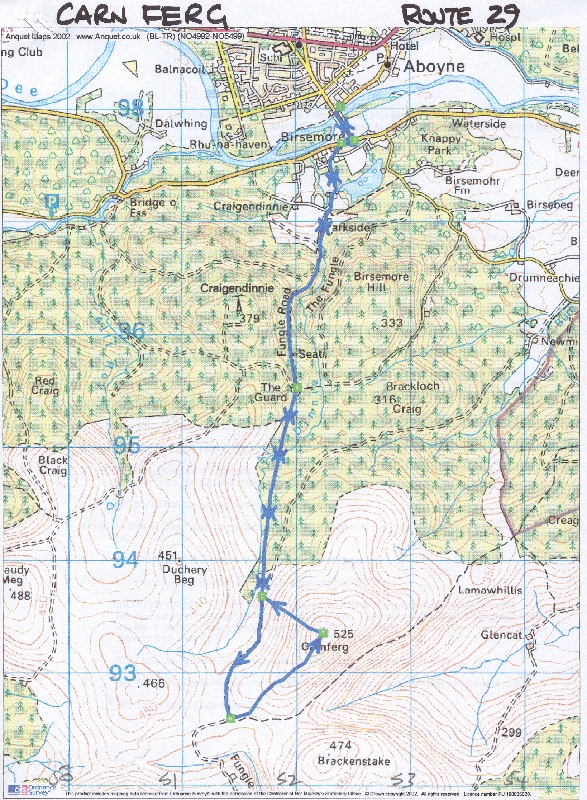
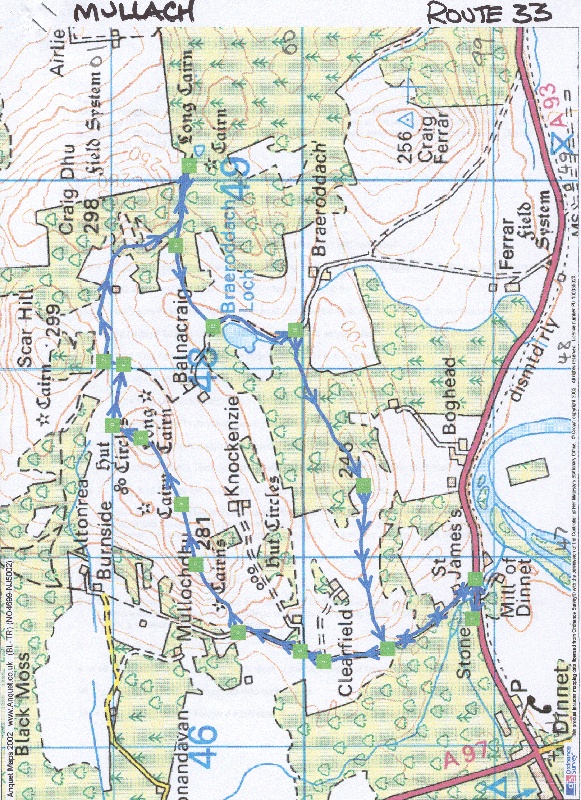
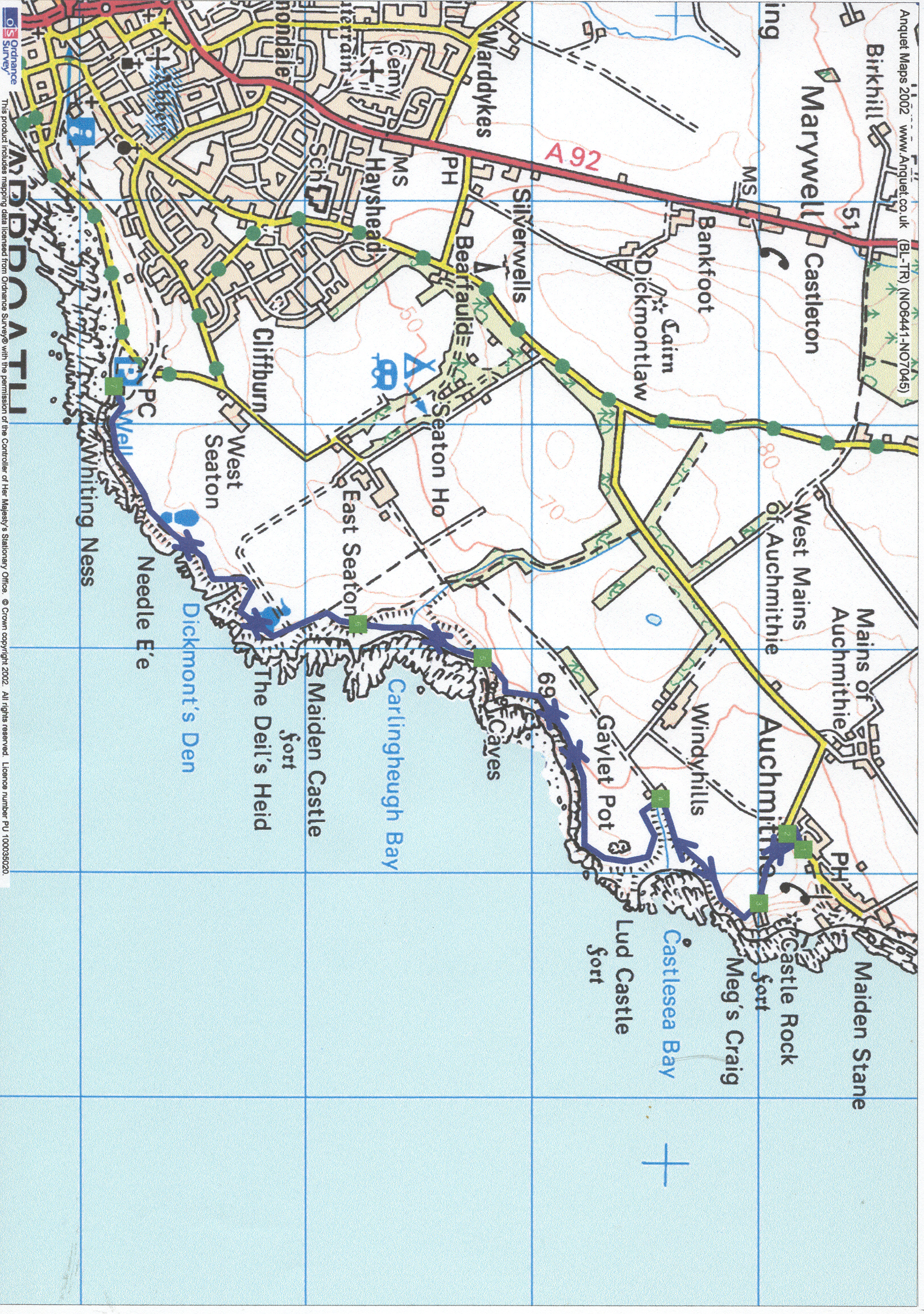
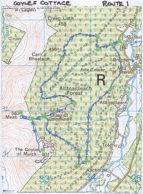
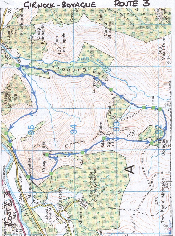
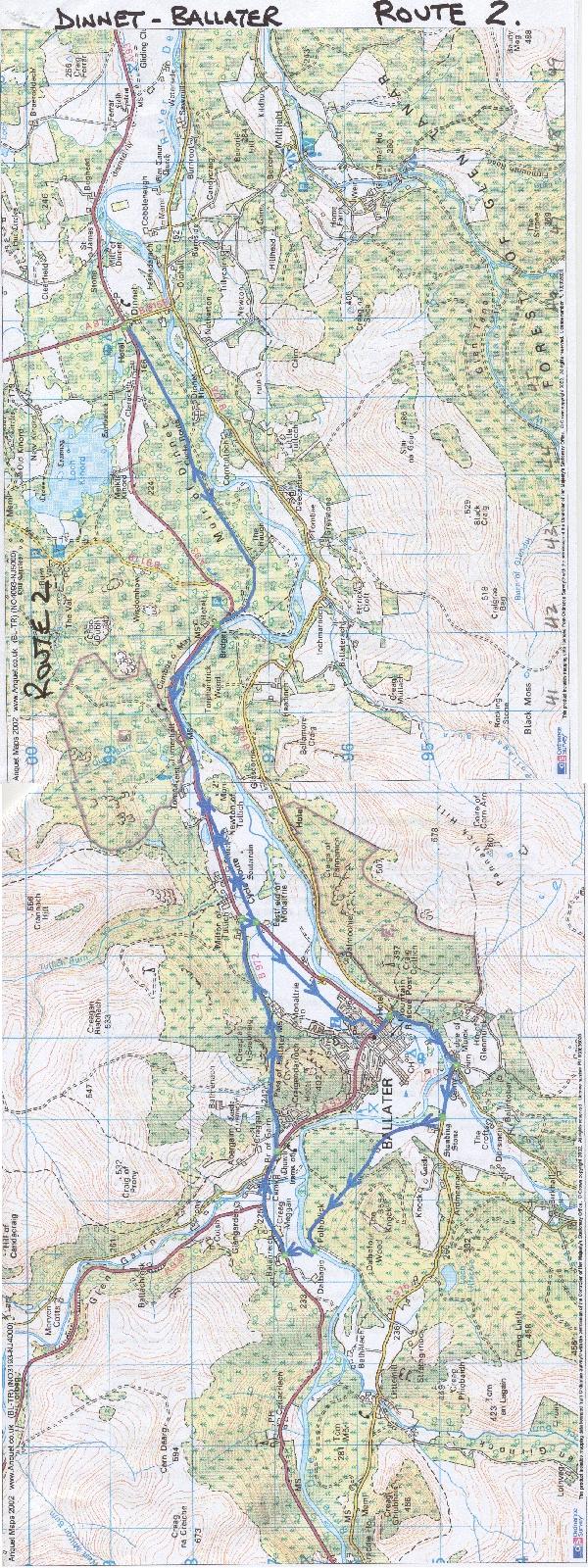
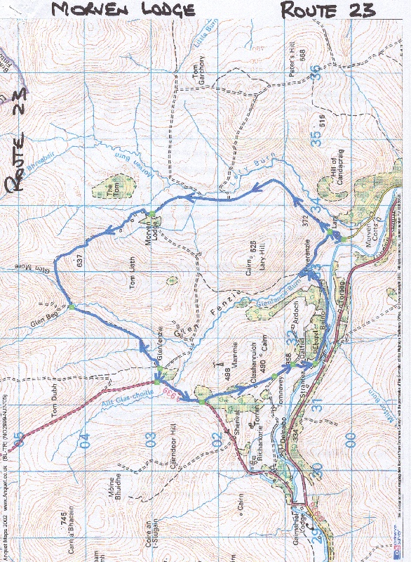
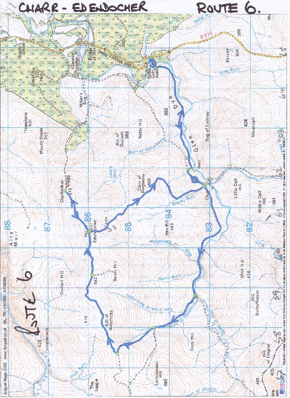
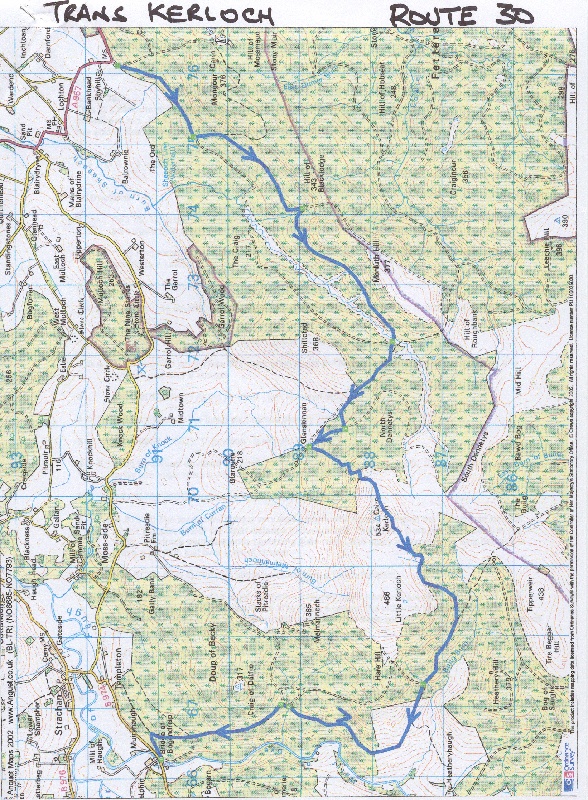
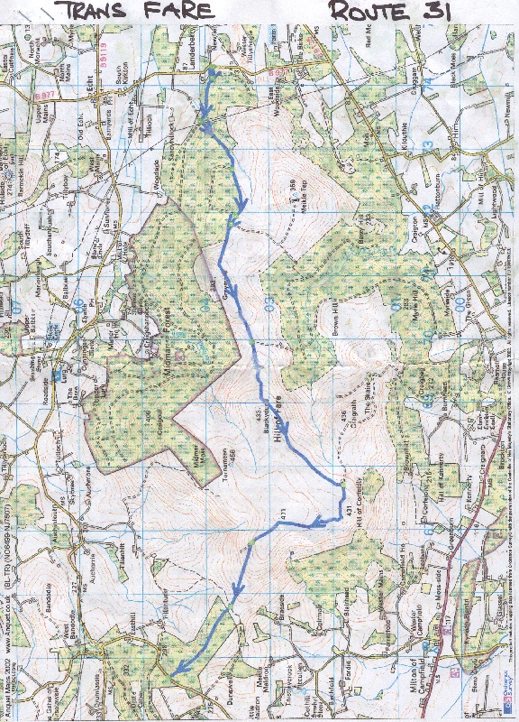
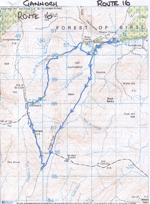
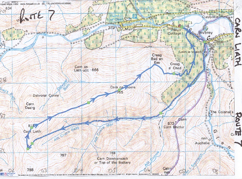
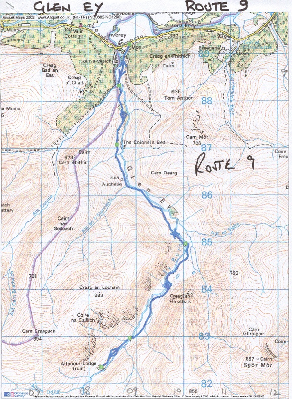
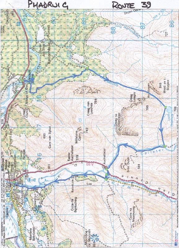
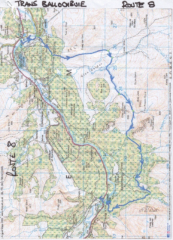
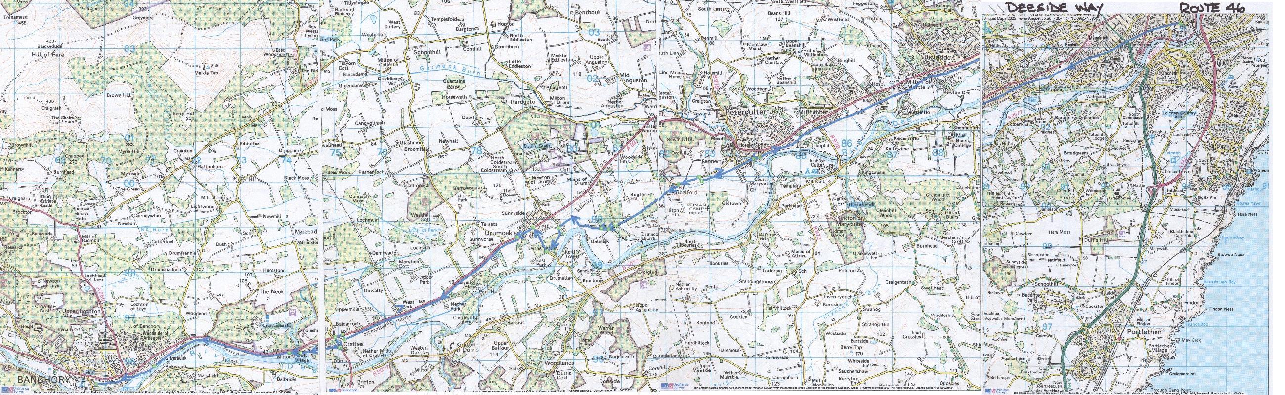
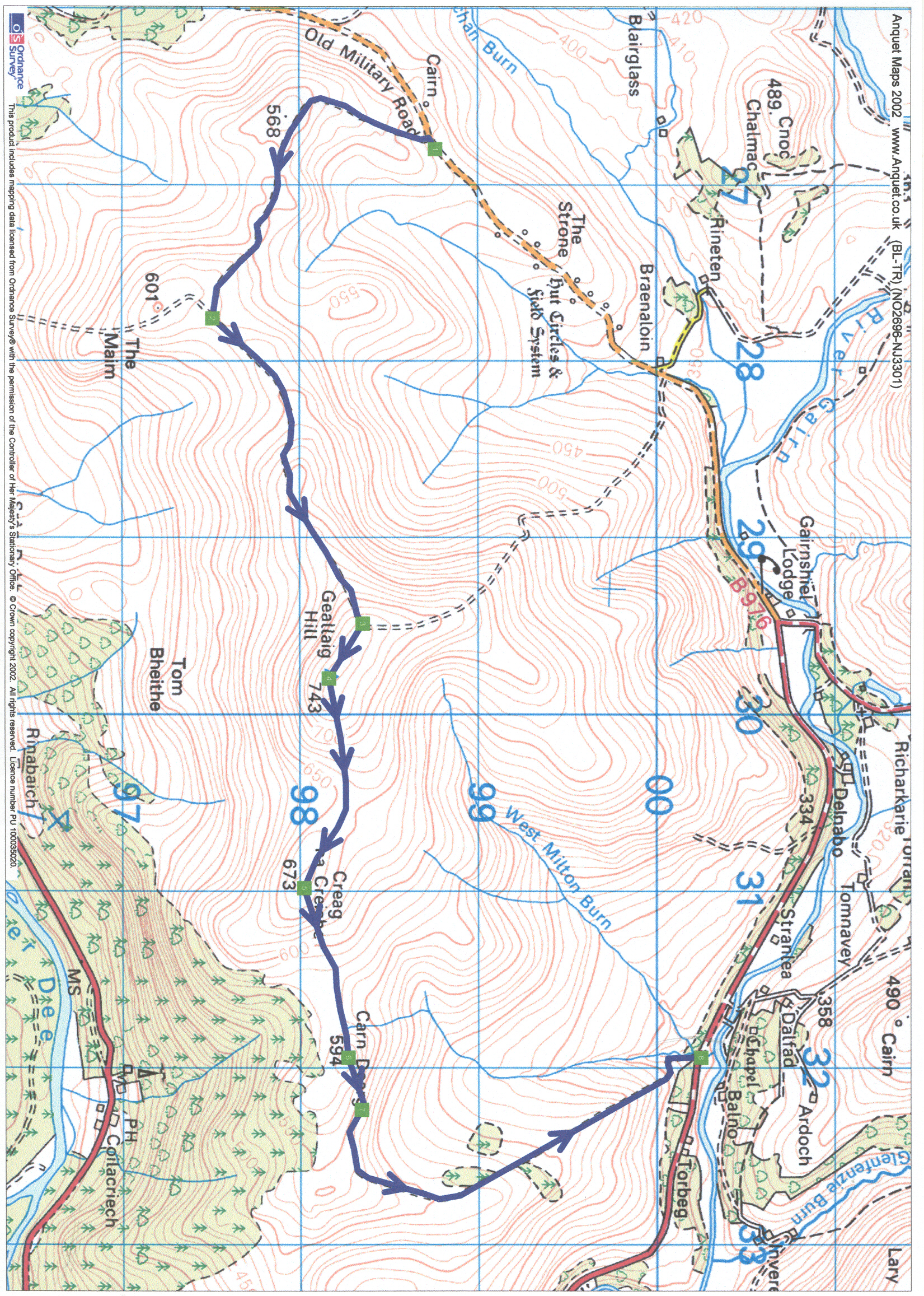
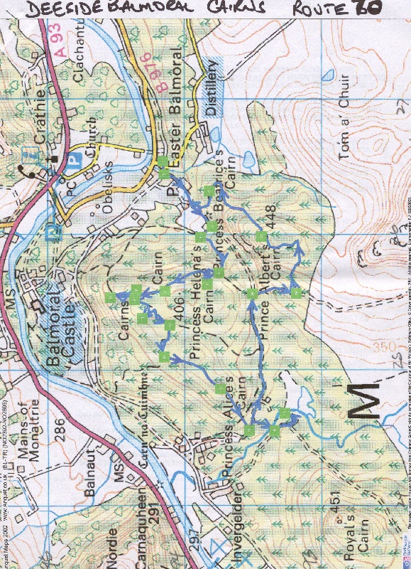
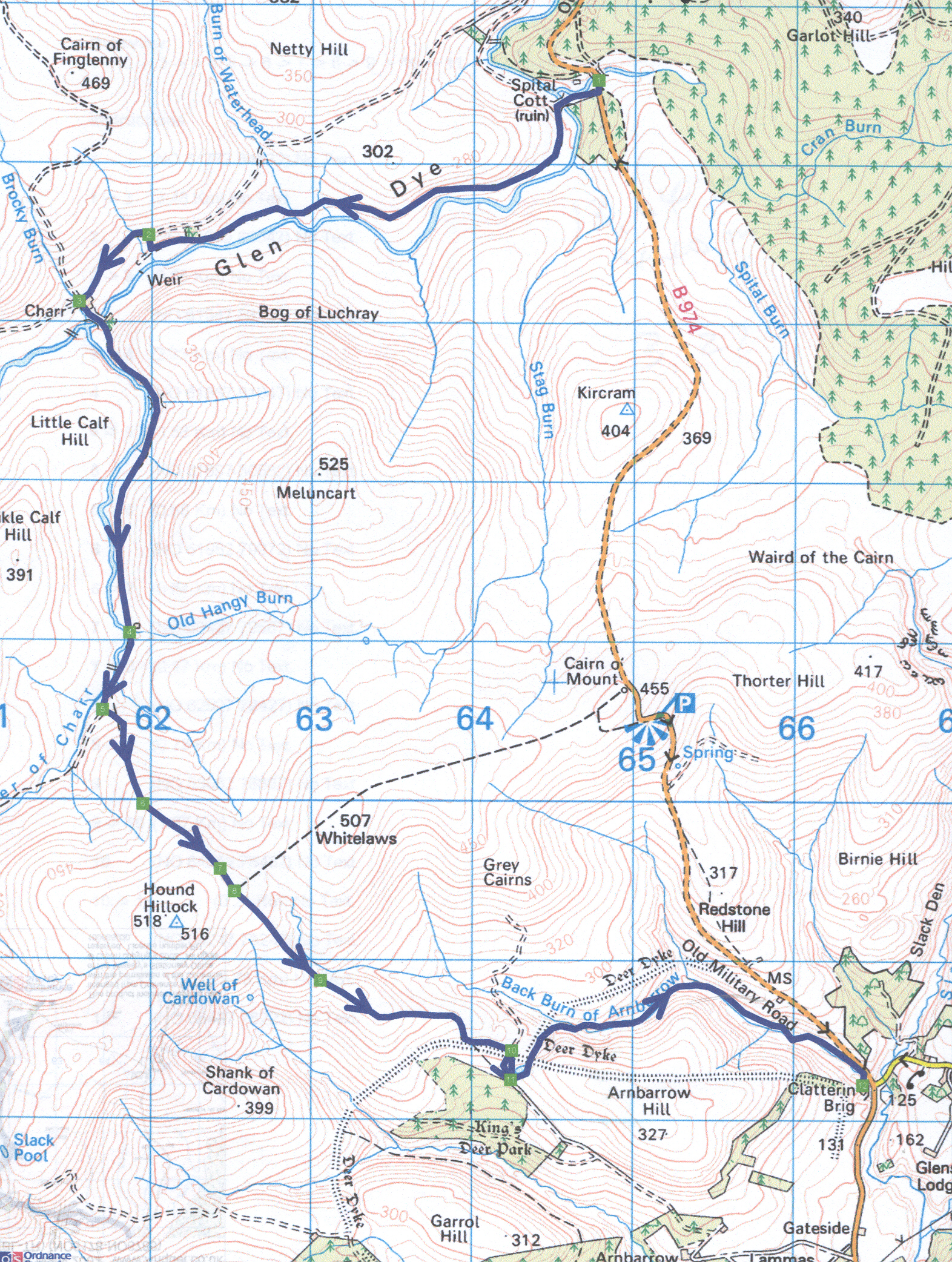
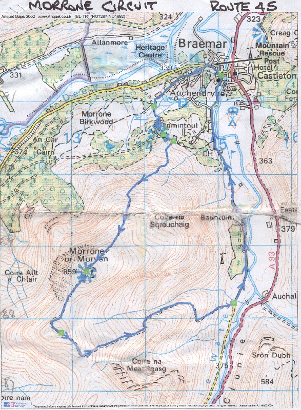
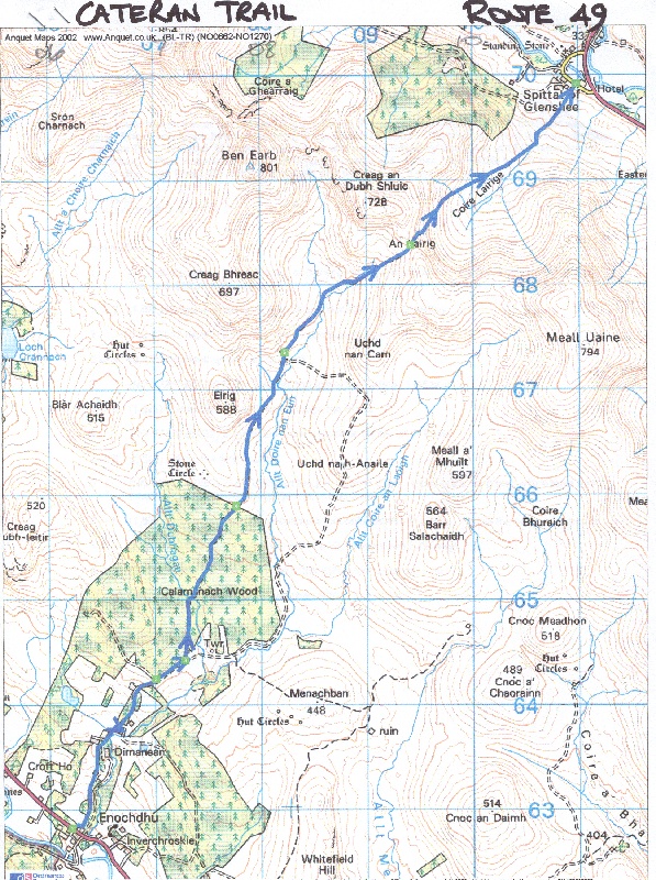
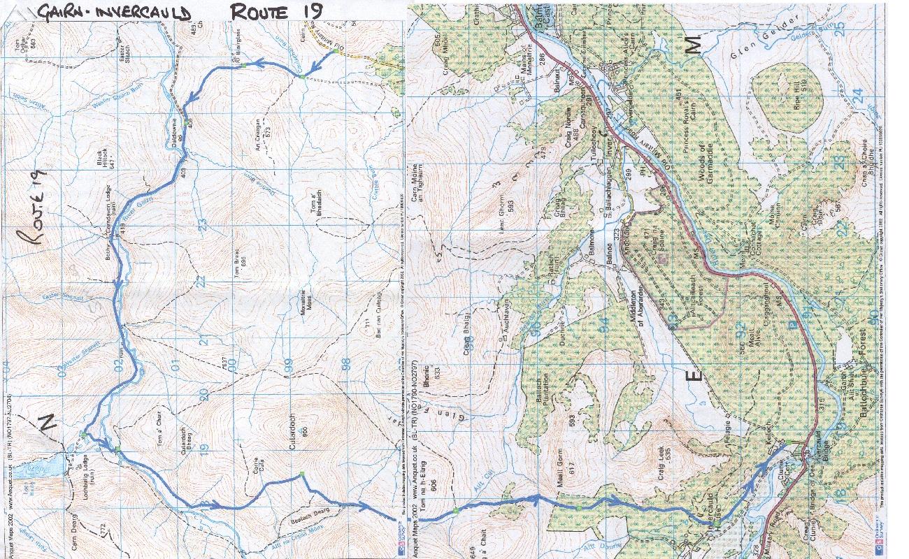
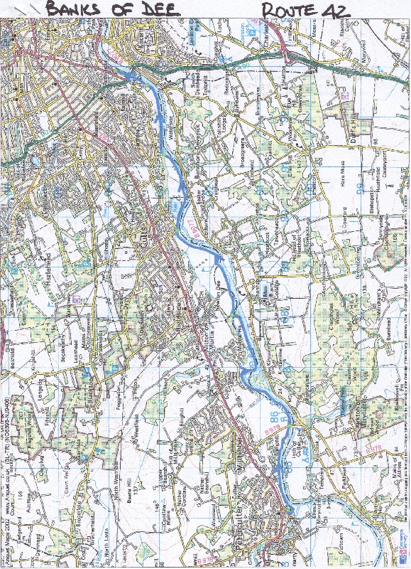
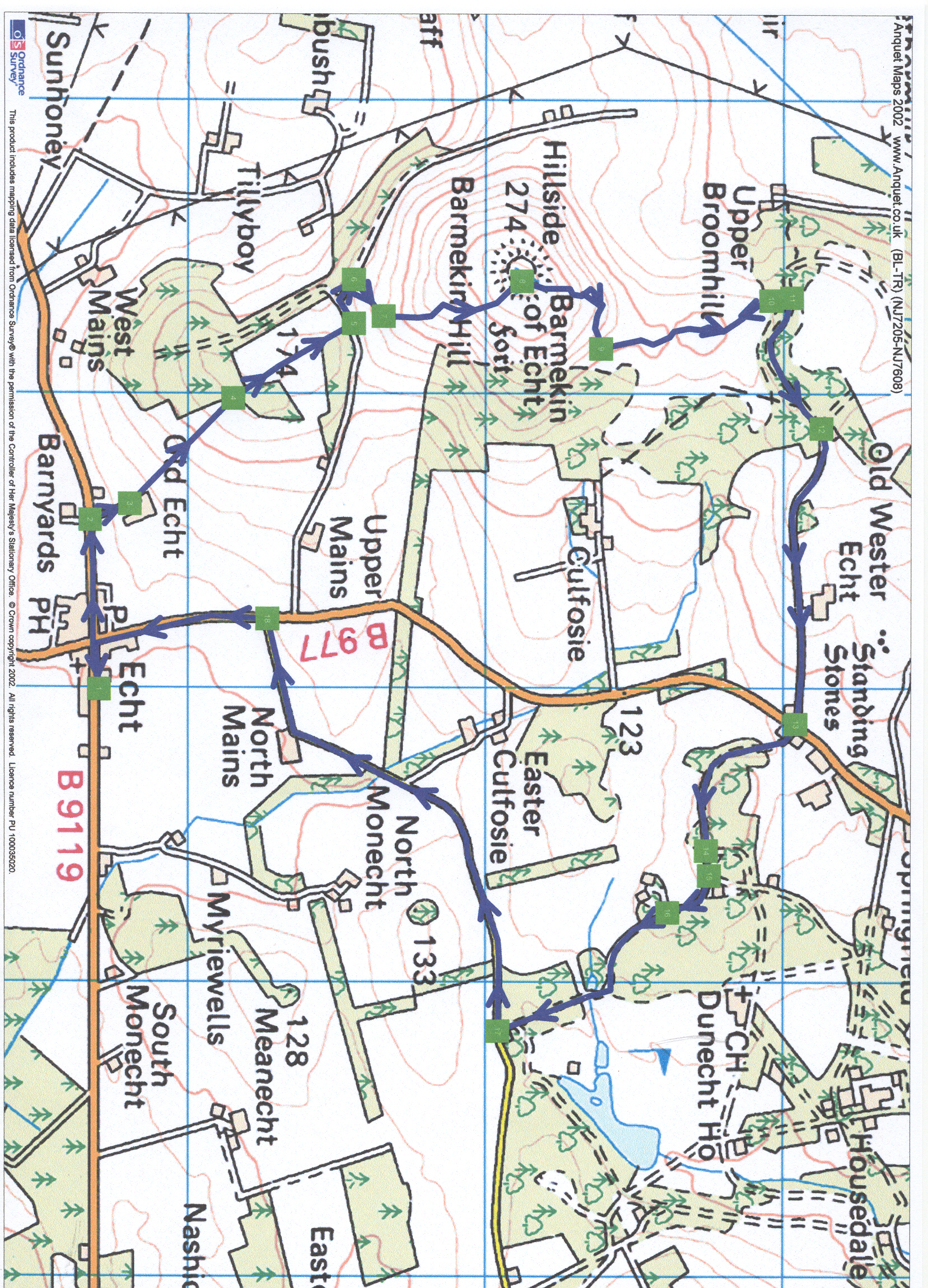
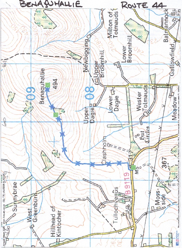
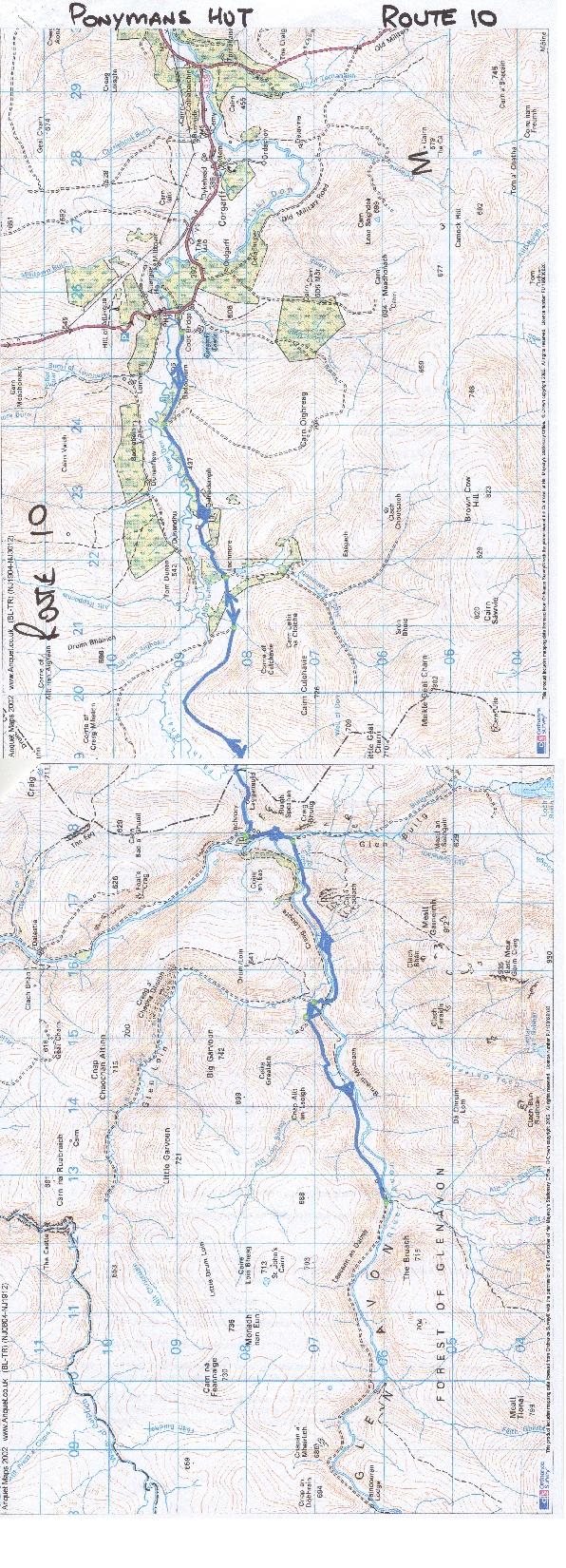
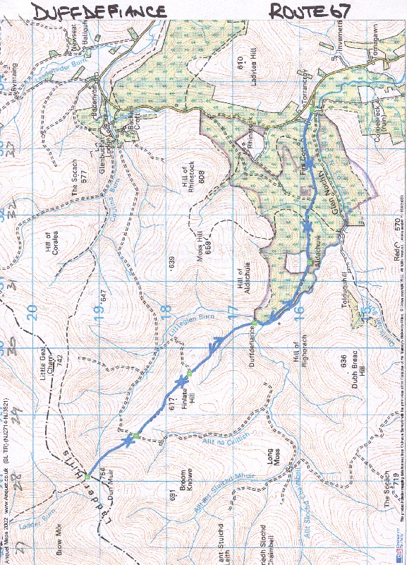
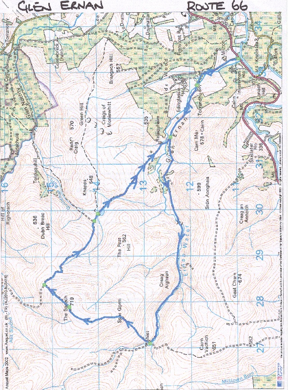
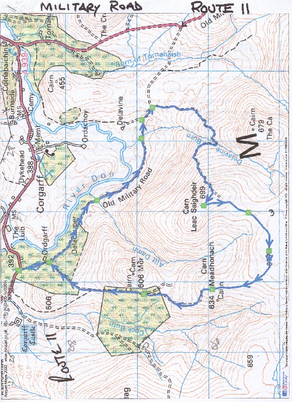
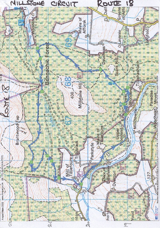
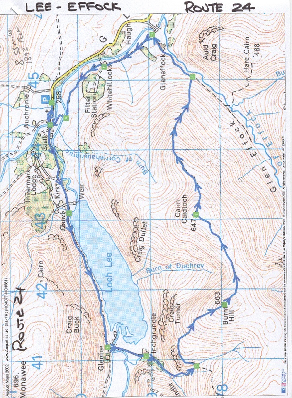
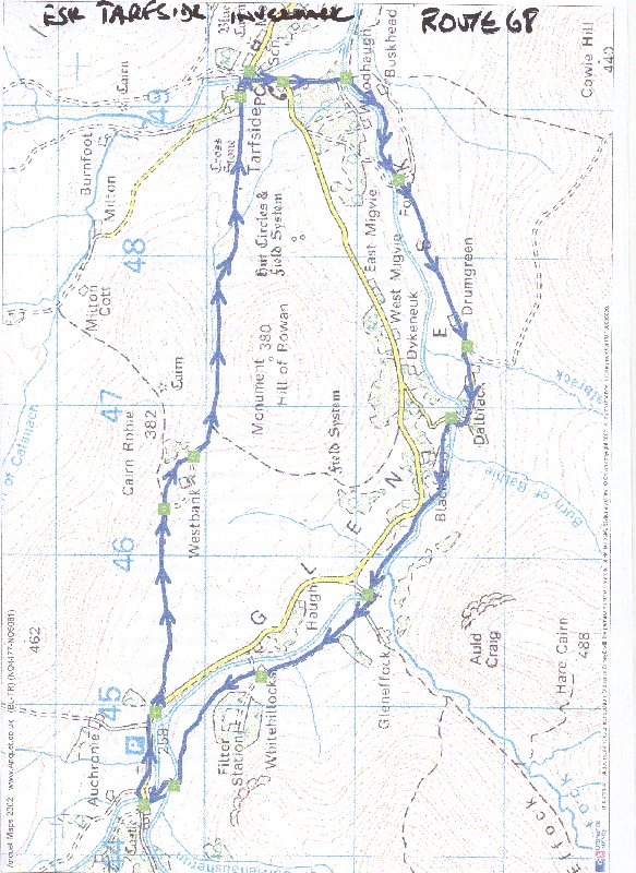
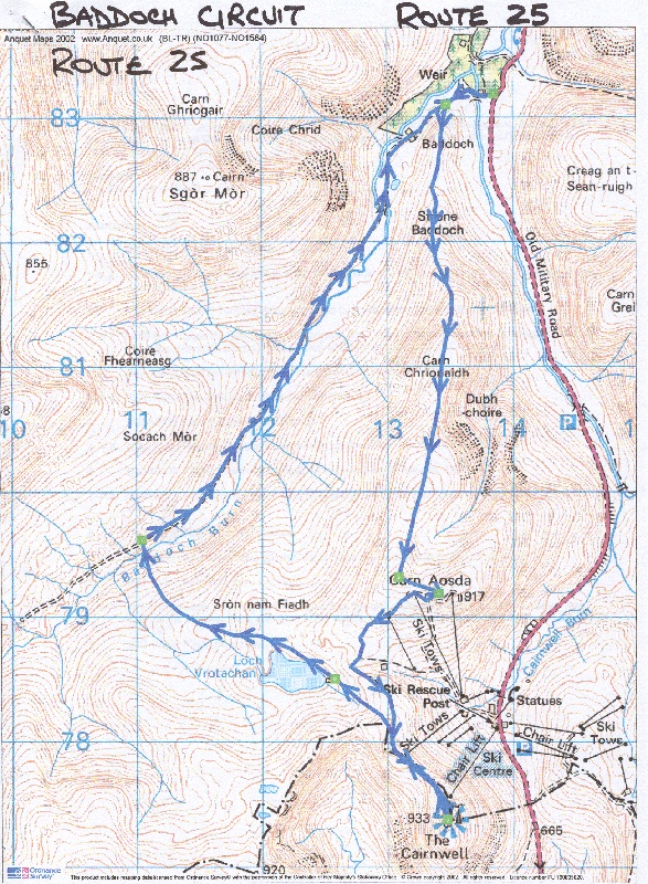
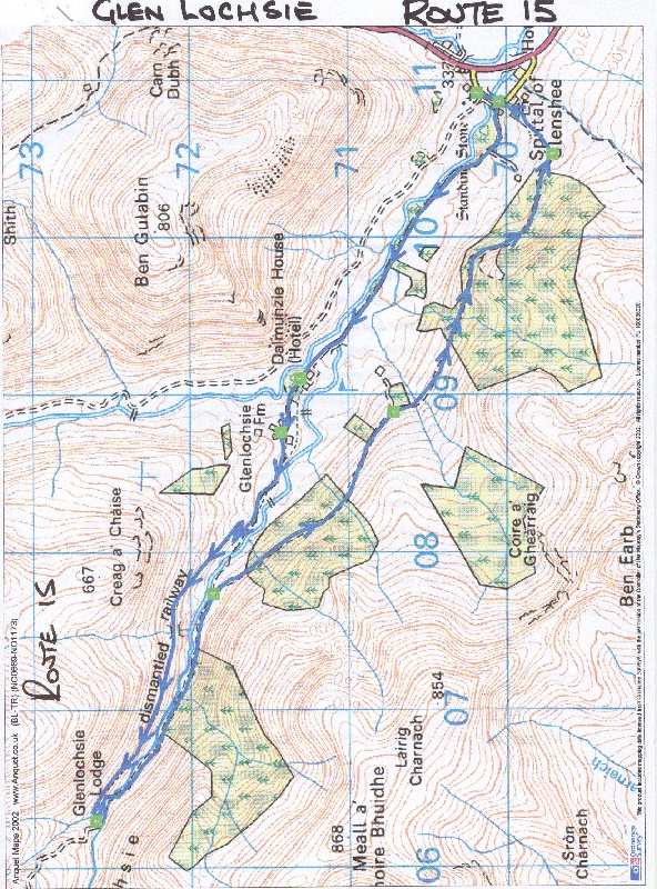
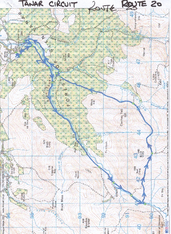
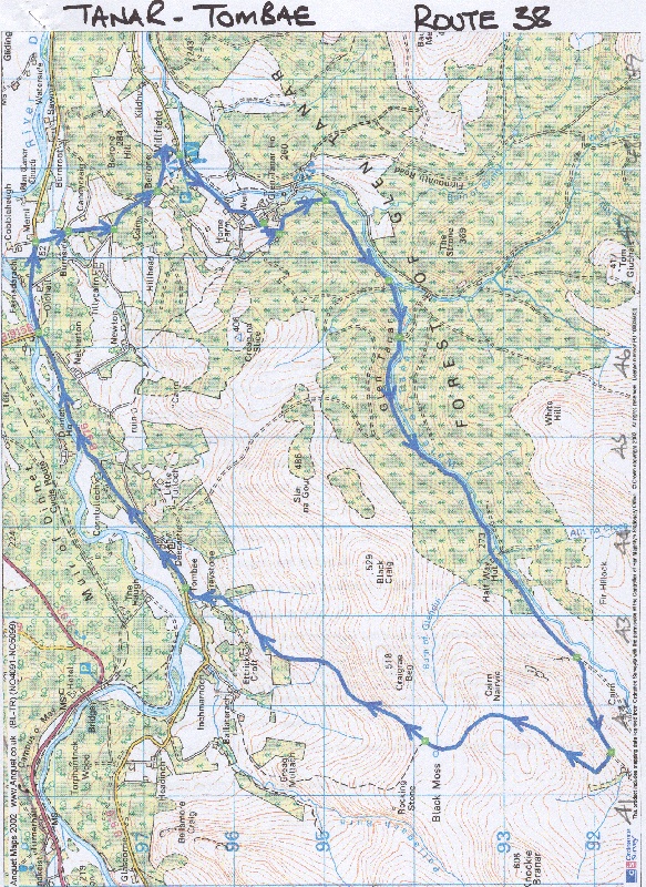
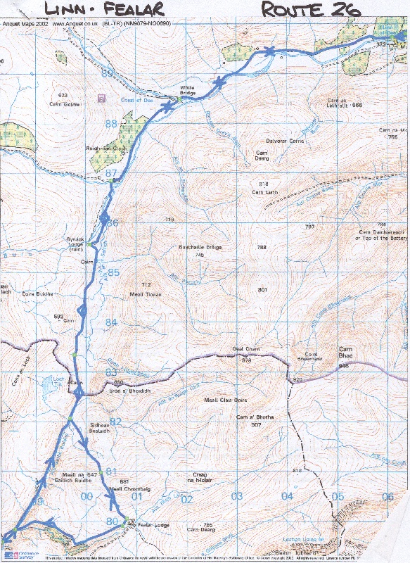
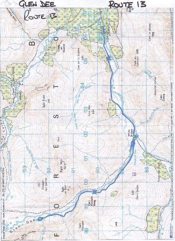
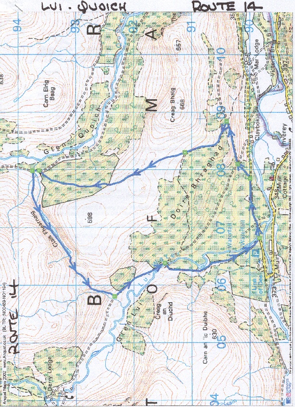
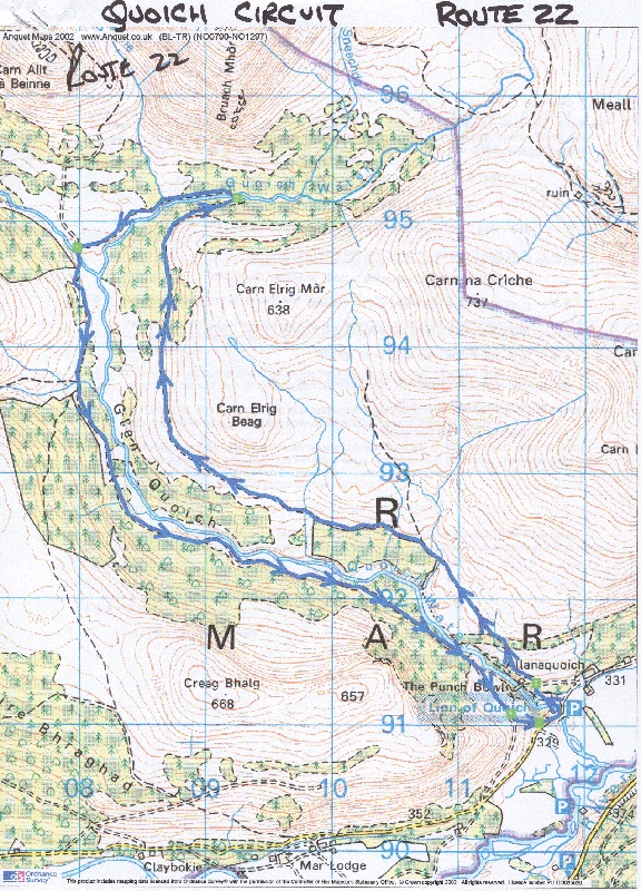
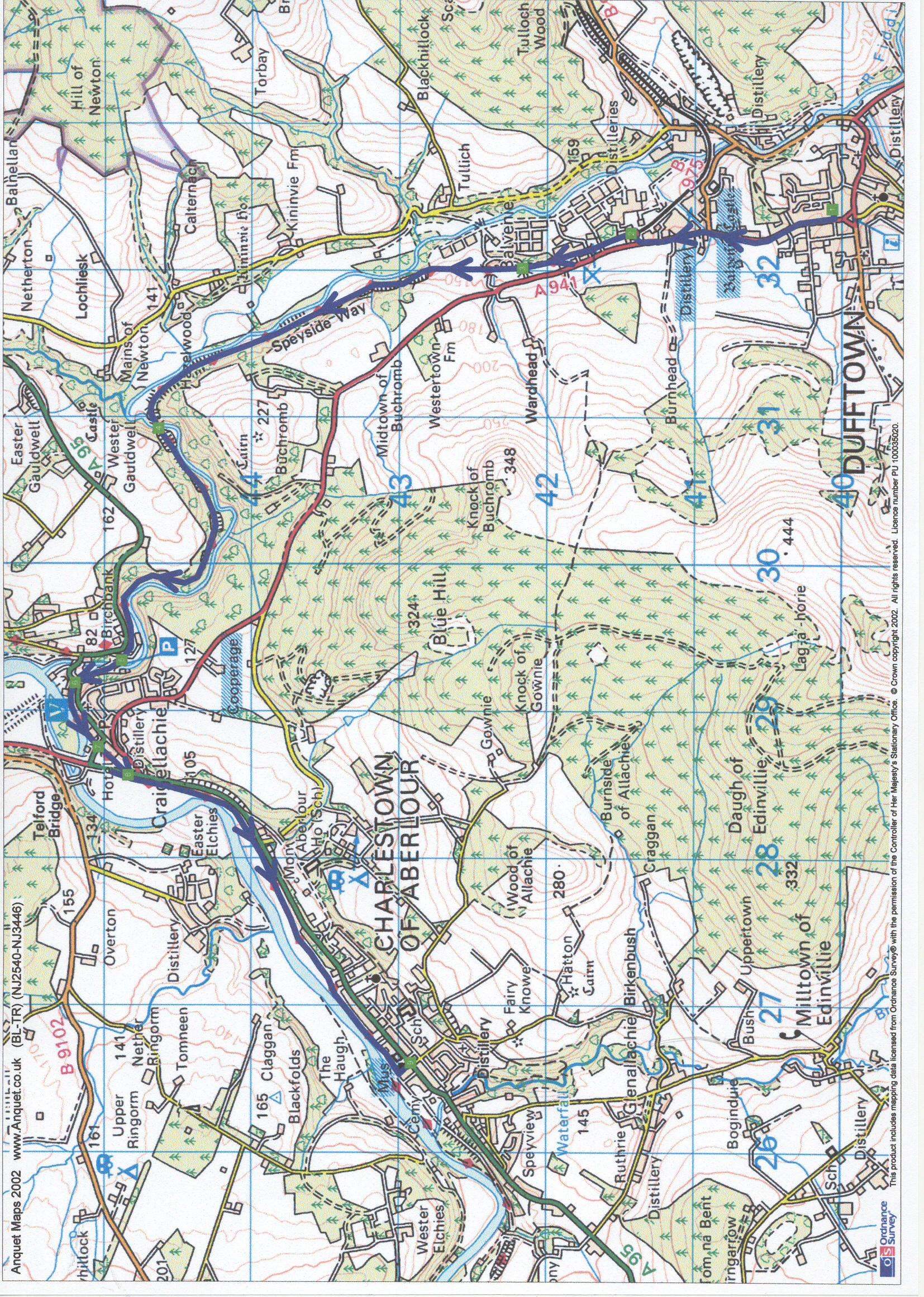
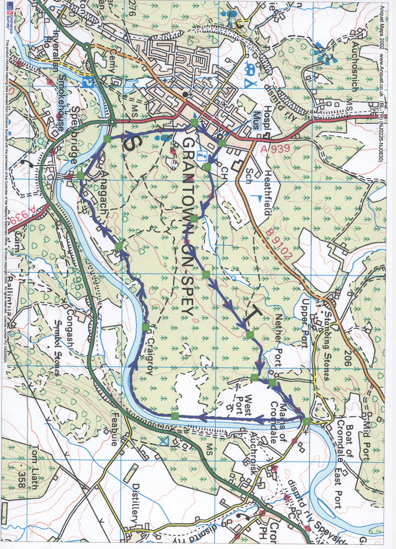
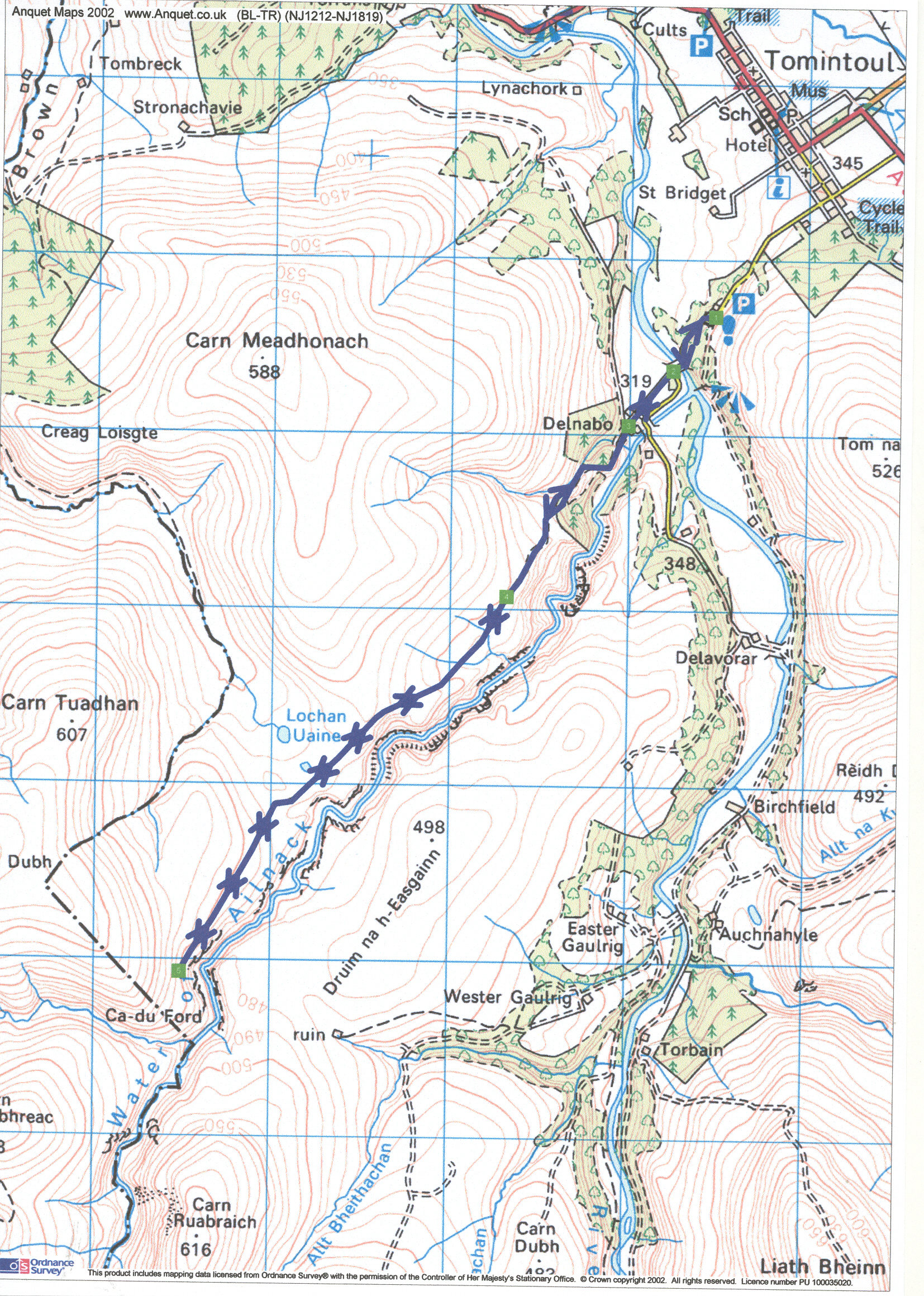
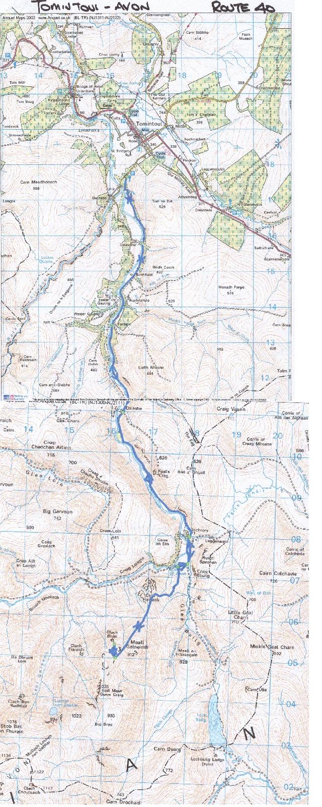