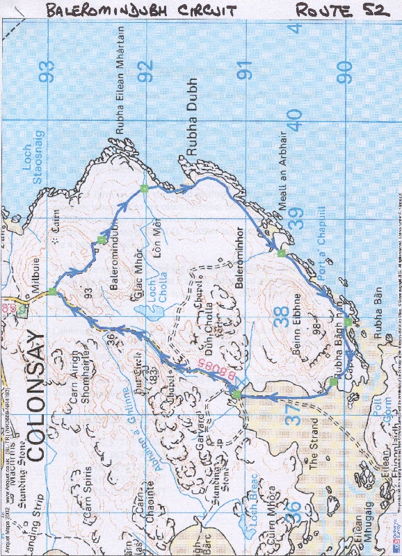
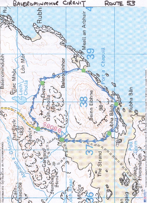
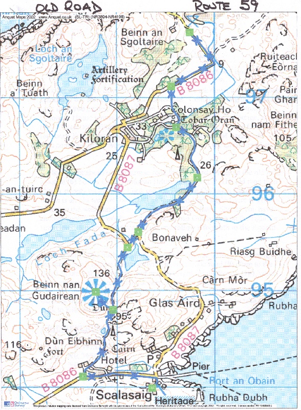
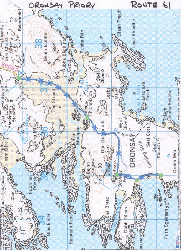
Peat and Heather Logo Peatandheather Banner
ROUTE 50  Back To Top
AN OUT AND RETURN WALK FROM GOLF COURSE TO ARDDSKENISH PENINSULA (OS EXPLORER SHEET 354)
An easy walk to the Ardskenish Promontory for fine views Dist=5 miles Time=2 hours
WAYPOINT  GRID  DISTANCE  DESCRIPTION 
Car Park (1) NR 35957 93957 0 Park just off the road near the golf course
Airfield (2) NR 35762 93222 0 At airfield follow path round perimeter to gain grassy path
Bay (3) NR 35182 92172 0 Ardskenish Bay - continue on grassy track to other side of peninsula
View (4) NR 34832 91352 0 View point for bird life - seals etc. Continue south to end of Headland
Point (5) NR 33672 90892 0 View the seals round Glas Eilean then back to waypoint (4)
View (4) NR 34832 91352 0 At this point head west over grassy meadow by fence and wall to beach
Dunes (6) NR 34472 91852 0 Here is the south end of Ardskenish Bay. Walk north along bay
Bay (3) NR 35182 92172 0 Joins outward route - return back to car park
           
JPEG Map
JPEG Map
Route CSV file
CSV Route File
Anquet Map file
Route Map File
Route text file
Text File
Photographs
Photos (5)
ROUTE 51  Back To Top
AN OUT AND RETURN WALK FROM GOLF COURSE TO ARDDSKENISH AND THE STRAND (OS EXPLORER SHEET 354)
An easy walk to the Ardskenish then crossing to the Strand. DO AT LOW TIDE Dist=7 miles Time=3 hours
WAYPOINT  GRID  DISTANCE  DESCRIPTION 
Car Park (1) NR 35957 93957 0 Park just off the road near the golf course
Airfield (2) NR 35762 93222 0 At airfield follow path round perimeter to gain grassy path
Bay (3) NR 35182 92172 0 Ardskenish Bay - continue on grassy track to other side of peninsula
View (4) NR 34832 91352 0 View point for bird life - seals etc. Head NE to bay
Bay (5) NR 35892 91437 0 Join rough landy - follow to a track junction
Junction (6) NR 36697 91242 0 Turn right at T junction down to the Strand
Strand (7) NR 37217 91082 0 Follow round west shore of Strand till rough ground prevents keeping to shore
Leave (8) NR 35477 90612 0 Leave Strand shore and head over rough ground to next bay then back to point (5)
Bay (5) NR 35892 91437 0 Join outward track - head back to car park
           
JPEG Map
JPEG Map
Route CSV file
CSV Route File
Anquet Map file
Route Map File
Route text file
Text File
Photographs
Photos (5)
ROUTE 52  Back To Top
A CIRCULAR WALK FROM THE STRAND (OS EXPLORER SHEET 354)
An easy walk taking in the Glen and round the east coast Dist= Time=
WAYPOINT  GRID  DISTANCE  DESCRIPTION 
Strand (1) NR 37217 91082 0 Park at the Strand Car Park then go back up the tarmac road
Track (2) NR 38257 92942 0 Take the Baleromindubh track and follow it to the farm
Farm (3) NR 38787 92447 0 Baleromindubh Farm - keep left and go through gate and down meadow
Pillars (4) NR 39312 92017 0 Go through old gate pillars and through gate to shore - head right above shore
Bay (5) NR 38657 90637 0 Cable Bay and stream estuary. Continue keeping on higher ground south
Bay (6) NR 37957 89962 0 Sandy Bay. Spend time here then continue round to Strand
Strand (7) NR 37347 90107 0 Strand joined. Walk bay over the Strand back to the car
Strand (1) NR 37217 91082 0 Car Park
           
JPEG Map
JPEG Map
Route CSV file
CSV Route File
Anquet Map file
Route Map File
Route text file
Text File
Photographs
Photos (4)
ROUTE 53  Back To Top
A CIRCULAR WALK FROM THE STRAND (OS EXPLORER SHEET 354)
An easy walk taking in the Glen and round the east coast Dist=3.7 miles Time=2 hours
WAYPOINT  GRID  DISTANCE  DESCRIPTION 
Strand (1) NR 37217 91082 0 Park at the Strand Car Park then go back up the tarmac road
Track (2) NR 37442 91577 0 Take the Balerominmhor track and follow it to the farm
Stone (3) NR 38397 91487 0 McFies Stone - investigate and continue past farm to shore
Bay (4) NR 38657 90637 0 Cable Bay and stream estuary. Continue keeping on higher ground south
Bay (5) NR 37957 89962 0 Sandy Bay. Spend time here then continue round to Strand
Strand (6) NR 37347 90107 0 Strand joined. Walk bay over the Strand back to the car
Strand (1) NR 37217 91082 0 Car Park
           
JPEG Map
JPEG Map
Route CSV file
CSV Route File
Anquet Map file
Route Map File
Route text file
Text File
Photographs
Photos (4)
ROUTE 54  Back To Top
AN OUT AND RETURN WALK FROM KILORAN BAY TO BALNAHARD BAY (OS EXPLORER SHEET 354)
A fairly demanding walk but a fantastic bay is reached at Balnahard Dist=7.5 miles Time=4 hours
WAYPOINT  GRID  DISTANCE  DESCRIPTION 
Kiloran (1) NR 39752 97677 0 Leave car park and descend to beach and head along it
Stile (2) NR 40362 98357 0 Go over stile then turn right and follow fence to track
Track (3) NR 40637 98247 0 Turn left and follow Balnahard Track
Grid (4) NR 40752 99427 0 Turn right 90 degrees and follow track past farm on your right
Barn (5) NR 42252 99882 0 At barn view old chapel ruins. Then through gate down to shore east end
Shore (6) NR 42952 99917 0 Shore east end - follow shore west to far end
Shore (7) NM 42857 372 0 View point - head back up valley to stream which you follow to a gate (8)
Gate (8) NM 42277 97 0 Go through gate - head for higher ground and head south to Port an Obain
Obain (9) NR 41082 99727 0 Beach - head up pasture to reach outward route at Grid (4)
Grid (4) NR 40752 99427 0 Join outward route. Head back to Kiloran and car park
           
JPEG Map
JPEG Map
Route CSV file
CSV Route File
Anquet Map file
Route Map File
Route text file
Text File
Photographs
Photos (5)
ROUTE 55  Back To Top
AN OUT AND RETURN WALK FROM KILORAN BAY TO CARNAN EOIN (OS EXPLORER SHEET 354)
An easy walk along the back but a pull up to Carnan Eoin (highest hill) Dist=3 miles Time=2 hours
WAYPOINT  GRID  DISTANCE  DESCRIPTION 
Kiloran (1) NR 39752 97677 0 Leave car park and descend to beach and head along it
Stile (2) NR 40362 98357 0 Go over stile then turn right and follow fence to track
Track (3) NR 40637 98247 0 Turn left and follow Balnahard Track
Point (4) NR 40662 98452 0 Leave track and head up grassy valley to col.
Col (5) NR 40797 98587 0 At col turn right up obvious footpath to gain summit
Trig (6) NR 40897 98487 0 Summit trig point and cairn. Return back downhill to Point (4)
Track (3) NR 40637 98247 0 Keep to the sandy landy track going over the dunes
Gate (7) NR 39957 97397 0 Gate onto main road. Turn right back to Kiloran car park
Grid (4) NR 40752 99427 0 Join outward route. Head back to Kiloran and car park
           
JPEG Map
JPEG Map
Route CSV file
CSV Route File
Anquet Map file
Route Map File
Route text file
Text File
Photographs
Photos (7)
ROUTE 56  Back To Top
AN OUT AND RETURN WALK FROM KILORAN BAY TO DUNAN NAN NIGHEAN (OS EXPLORER SHEET 354)
A roughish walk across to the east coast and ancient site Dist=4 miles Time=2 hours
WAYPOINT  GRID  DISTANCE  DESCRIPTION 
Kiloran (1) NR 39752 97677 0 Leave car park and descend to beach and head along it
Stile (2) NR 40362 98357 0 "Go over stile then turn right and follow fence,cross track and follow fence to gate"
Gate (3) NR 40747 97907 0 Through gate and follow track round grassy hillock to ruin
Ruin (4) NR 41087 97837 0 Ruin. Make for higher ground with footpaths heading east
Dunan (5) NR 41562 97632 0 Dunan nan Nighean. Investigate and return back to gate (3)
Gate (3) NR 40747 97907 0 Through gate then head over grassy ground to join grassy landy track to main road
Road (6) NR 39957 97397 0 Gate onto main road. Turn right back to Kiloran car park
Kiloran (1) NR 39752 97677 0 Car Park
           
JPEG Map
JPEG Map
Route CSV file
CSV Route File
Anquet Map file
Route Map File
Route text file
Text File
Photographs
Photos (3)
ROUTE 57  Back To Top
AN CIRCULAR WALK FROM GOLF COURSE TO TO DUN GHALLAIN (OS EXPLORER SHEET 354)
An easy walk to the Dun Ghallain for fine views Dist=2.6 miles Time=1.5 hours
WAYPOINT  GRID  DISTANCE  DESCRIPTION 
Car Park (1) NR 35957 93957 0 Park just off the road near the golf course
Airfield (2) NR 35762 93222 0 At airfield follow path round perimeter to gain grassy path then head for Port Lobh
Lobh (3) NR 35602 92907 0 Investigate Port Lobh then head up to Dun Ghallain
Dun (4) NR 35027 93157 0 Dun Ghallain. Fine views - head down to Traigh an Tobair Fhuair
Bay (5) NR 35577 93602 0 Investigate bay and maybe old lookout tower. Return back to car
Car Park (1) NR 35957 93957 0 Car Park
           
JPEG Map
JPEG Map
Route CSV file
CSV Route File
Anquet Map file
Route Map File
Route text file
Text File
Photographs
Photos (3)
ROUTE 58  Back To Top
AN OUT AND RETURN WALK FROM KILCHATTAN TO MEALL LAMALUM (OS EXPLORER SHEET 354)
A demanding walk to a fine peninsula at Meall Lamalum Dist=4 miles Time=2 hours
WAYPOINT  GRID  DISTANCE  DESCRIPTION 
Cemetery (1) NR 36312 94992 0 Cemetery Car Park. Walk north up the tarmac road to Gortain track
Track (2) NR 36872 95232 0 Gortain track. Take this track - walk to left of cottage to a gate
Gate (3) NR 36667 95642 0 "Go through gate,turn left and contour round using obvious path to lochan"
Lochan (4) NR 36697 96107 0 At lochan crab uphill on track to a col having crossed a small stream
Col (5) NR 36962 96652 0 Skirt small hillock to gain wide valley leading down to promontory
Meall (6) NR 36852 97017 0 Promontory. Investigate headland and Andora Star plaque. Return to col
Col (5) NR 36962 96652 0 Strike south uphill to Binnein Riabach
Peak (7) NR 36417 96262 0 Summit of hill giving fine views. Head east back down to gate
Gate (3) NR 36667 95642 0 Join outward route - head back to road and cemetery
Cemetery (1) NR 36312 94992 0 Car Park
           
JPEG Map
JPEG Map
Route CSV file
CSV Route File
Anquet Map file
Route Map File
Route text file
Text File
Photographs
Photos (3)
ROUTE 59  Back To Top
AN OUT AND RETURN WALK FROM KILORAN BAY TO SCALASAIG (OS EXPLORER SHEET 354)
A longish walk covering the old road connecting Colonsay House with Scalasaig Dist=7.5 miles Time=3 hours
WAYPOINT  GRID  DISTANCE  DESCRIPTION 
Car Park (1) NR 39752 97677 0 Kiloran Bay car park. Walk back along the tarmac road entering the tree area
Gate (2) NR 39562 97117 0 Go though gate on the left - footpath to tennis courts - follow sign for Avenue Cottage
Junction (3) NR 39612 96692 0 "Turn left past Avenue and follow track right,left and right again"
Gate (4) NR 39827 96167 0 Keep on track past gate along east shore of Loch Fada
Road (5) NR 39222 95607 0 Join tarmac road - straight on down hill to old road starts again
Road (6) NR 39112 95447 0 Rejoin old road at Loch Turraman. Continue up hill. Look out for old well on left
Path (7) NR 38962 94802 0 Leave old road and strike up path on right to Beinn nan Guidairean.
Summit (8) NR 38787 94987 0 Summit trig and view indicator. Return back to old road and continue downhill
Road (9) NR 38652 94112 0 Reach tarmac road near the Hotel. Turn left and walk down road to pier and Pantry
Pantry (10) NR 39362 93992 0 Pantry for refreshments. Retrace steps to Kiloran missing out Beinn nan Guidairean
Car Park (1) NR 39752 97677 0 Kiloran Bay Car park.
           
JPEG Map
JPEG Map
Route CSV file
CSV Route File
Anquet Map file
Route Map File
Route text file
Text File
Photographs
Photos (15)
ROUTE 60  Back To Top
A CIRCULAR WALK FROM THE STRAND TO ORONSAY EAST (OS EXPLORER SHEET 354)
An easy walk round some fantastic bays. Check tides before the walk Dist=5.7 miles Time=2 hours
WAYPOINT  GRID  DISTANCE  DESCRIPTION 
Strand (1) NR 37217 91082 0 Strand car park. Walk round east shore to point (2)
Shore (2) NR 37347 90107 0 "As tide goes out,seaweed floats - crossing possible now. Head for post,then east"
Shore (3) NR 37267 89587 0 Go up grassy bank on Oronsay and over machair to sandy bay then follow beaches
Headland (4) NR 37897 88832 0 "Climb up to headland for views,then continue round bays and above shore to ruin"
Cottage (5) NR 36187 88137 0 Seal Cottage just beyond Coal House ruin. Follow farm track to tarmac road
Gate (6) NR 35952 88937 0 Gate leading to tarmac road. Turn right back to Strand
Strand (7) NR 36317 89547 0 Edge of Strand. Cross back to car park - look for Sanctuary Cross
Strand (1) NR 37217 91082 0 Strand car park.
           
JPEG Map
JPEG Map
Route CSV file
CSV Route File
Anquet Map file
Route Map File
Route text file
Text File
Photographs
Photos (10)
ROUTE 61  Back To Top
A OUT AND RETURN WALK FROM THE STRAND TO ORONSAY PRIORY (OS EXPLORER SHEET 354)
An easy walk to Oronsay Priory and sandy bay. Check tides before the walk Dist=6 miles Time=2 hours
WAYPOINT  GRID  DISTANCE  DESCRIPTION 
Strand (1) NR 37217 91082 0 Strand car park. Walk across towards pole on Oronsay when safe to do so
Pole (2) NR 36317 89547 0 Pole on Oronsay indicating start of vehicle track - follow track
Priory (3) NR 35017 88887 0 Oronsay Priory - investigate then down path towards memorial and gates to beach
Beach (4) NR 34897 88437 0 Long sandy beach. Walk along beach to far end
Beach (5) NR 35012 87897 0 Far end of beach - return back to tarmac road and thence to Strand
Pole (2) NR 36317 89547 0 Edge of strand. Cross back to car park
Strand (1) NR 37217 91082 0 Strand car park.
           
JPEG Map
JPEG Map
Route CSV file
CSV Route File
Anquet Map file
Route Map File
Route text file
Text File
Photographs
Photos (8)
ROUTE 62  Back To Top
AN OUT AND RETURN WALK FROM KILCHATTAN TO PORT MHOR CLIFFS (OS EXPLORER SHEET 354)
A roughish walk to viewpoint of cliff scenery Dist=3 miles Time=1.5 hours
WAYPOINT  GRID  DISTANCE  DESCRIPTION 
Cemetery (1) NR 36312 94992 0 Cemetery Car Park. Walk north up the tarmac road to Gortain track
Bay (2) NR 36197 94802 0 Rough vehicle track to right - follow then down to shore and follow footpath at fence
Peninsula (3) NR 35467 95092 0 Follow fence and make for wide grassy valley over a stream
Circle (4) NR 36092 95972 0 Stone circle - continue to promontory
View (5) NR 36137 96237 0 View point. Keep children under control as it can be dangerous. Return back
Cemetery (1) NR 36312 94992 0 Car Park
           
JPEG Map
JPEG Map
Route CSV file
CSV Route File
Anquet Map file
Route Map File
Route text file
Text File
Photographs
Photos (5)
ROUTE 63  Back To Top
AN OUT AND RETURN WALK FROM KILORAN BAY TO PORT AN OBAIN (OS EXPLORER SHEET 354)
A longish walk taking in two small bays to the north of Kiloram Dist=5 miles Time=2 hours
WAYPOINT  GRID  DISTANCE  DESCRIPTION 
Kiloran (1) NR 39752 97677 0 Leave car park and descend to beach and head along it
Stile (2) NR 40362 98357 0 Go over stile then turn right and follow fence to track
Track (3) NR 40637 98247 0 Turn left and follow Balnahard Track
Whale (4) NR 40752 99427 0 Port Sgibinis and whale - head up grassy hill to headland
Headland (6) NR 42252 99882 0 Headland - take care - return to track then over cattle grid and left down meadow
Obain (5) NR 41082 99727 0 Rocky shore with small stream. Return back via outward route
Kiloran (1) NR 39752 97677 0 Kiloran car park
           
JPEG Map
JPEG Map
Route CSV file
CSV Route File
Anquet Map file
Route Map File
Route text file
Text File
Photographs
Photos (6)
ROUTE 64  Back To Top
AN OUT AND RETURN WALK FROM KILORAN BAY TO RAISG BUIDHE and PORT OLMSA (OS EXPLORER SHEET 354)
A rough walk demanding navigation skills Dist=5 miles Time=3 hours
WAYPOINT  GRID  DISTANCE  DESCRIPTION 
Car Park (1) NR 39752 97677 0 Kiloran Bay car park. Walk back along the tarmac road entering the tree area
Gate (2) NR 39562 97117 0 Go though gate on the left - footpath to tennis courts - follow sign for Avenue Cottage
Junction (3) NR 39612 96692 0 "Turn left past Avenue and follow track right,left and right again"
Gate (4) NR 39827 96167 0 Go through gate on left and follow rough boggy track over the hill to village
Village (5) NR 40597 95517 0 Raisg Buidhe - investigate then skirt hill north to stream and Port Olmsa
Olmsa (6) NR 40947 96212 0 Port Olmsa. Seals bask on rocky shore. Head over rough ground to gate
Gate (2) NR 39562 97117 0 Reach outward gate leading to Old Road. Turn right back to car park
Car Park (1) NR 39752 97677 0 Kiloran Bay Car park.
           
JPEG Map
JPEG Map
Route CSV file
CSV Route File
Anquet Map file
Route Map File
Route text file
Text File
Photographs
Photos (7)
ROUTE 65  Back To Top
AN OUT AND RETURN WALK FROM KILORAN BAY TO URAGAIG PENINSULA (OS EXPLORER SHEET 354)
An easy walk to give fine views of sea birds and coastalm scenery Dist=4 miles Time=2 hours
WAYPOINT  GRID  DISTANCE  DESCRIPTION 
Car Park (1) NR 39752 97677 0 Kiloran Bay car park. Walk west up the tarmac road past Uragaig hamlet
Gate (2) NR 38812 98242 0 Gate just before last house - go through then right up grassy field to stile
Stile (3) NR 38732 98427 0 "Cross stile and head right,taking care,to headland."
Headland (4) NR 38817 98487 0 Headland for views. Take care - not for the faint hearted. Return to stile
Stile (3) NR 38732 98427 0 Recross stile then follow fence south to another stile to cross to fort
Fort (5) NR 38207 98092 0 Dun Tealtaig. Take care again here. Fine views
Gate (2) NR 38812 98242 0 Go through gate back to main vehicle track then back to car park
Car Park (1) NR 39752 97677 0 Kiloran Bay Car park.
           
JPEG Map
JPEG Map
Route CSV file
CSV Route File
Anquet Map file
Route Map File
Route text file
Text File
Photographs
Photos (4)


Valid HTML 4.01 Transitional About Us | Contact Us ©2005,2007 PeatandHeather
Corndavon Builg Cycle
Corgarff to Inchrory
Deeside Balmoral Cairns
Deeside Railway Line Cycle
Fealar Tilt
Formantine Way Cycle Run
Glen Muick Cycle Run
Glen Dee Cycle ROUTE
Glen Dye Circular ROUTE
Glen Ey Cycle ROUTE
Glen Quoich Cycle
Glen Tanar Circular
Glen Tanar Etnach
Inverbervie to Johnshaven
Kerloch Cycling Circuit
Millstone Hill Cycle ROUTE
Deskry Eagle North Morven Cycle(5)
Donside Well of Don (43)
Deeside way Aberdeen Banchory (46)
Tomintoul Ailnack (72)
Ballater Geallaig Crossing (73)
Echt Barmekan Hill Fort (74)
Angus Auchmithie Arbroath (75)
Ballater Glen Bardy (76)
Speyside Grantown Anagach (77)
Speyside Dufftown Aberlour (78)
Glen Dye Clattering Brig (79)
Ballindalloch Aberlour (80)
Lumphanan Potarch (81)
Glen Esk Lethnot Wirren (41)
Glen Esk Milden Tarfside (69)
Glen Esk Tarfside Invermark (68)
Deeside Culter Aberdeen (42)
Deeside Balmoral Cairns (66)
Donside Benaqhallie (44)
Deeside Braemar Morrone (45)
Deeside Cataran Trail (49)
Donside Carn Ealasaig (47)
Donside Duff Defiance (67 )
Donside Glen Ernan (70 )
Deeside Glenshee Ridge (48)
BallochBuie Forest Walk (8)
Balnamoons Cave (12)
Ben Avon (40)
Cairwell Walk (25)
Carn Ferg Walk (29)
Castle Wilson (27)
Carn liath and Glen Christie (7)
Coyles of Muick Walk (1)
Craig nam ban (3)
Creag Nan Gabhar (34)
Dinnet Nature Reserve (17)
Falls of Damff (4)
Fungle and Firmounth (16)
Glen Ey Cycle ROUTE (9)
Glen Lochsie (15)
Glen Nochty (32)
Glen Quioch Walk (14)
Hill of Fare Near Banchory (31)
Invercauld to Glen Callater (39)
Loch Lee and Glen Effock (24)
Loch Muick Walk (28)
Methlick to the Braes of Gight (37)
Military Road Wade Bridge (11)
Morven and Glen Fenzie (23)
Muir of Dinnet Walk (17)
Mullachdhu (33)
Donside Well of Don (43)
Deeside way Aberdeen Banchory (46)
Corndavon Builg Cycle (19)
Corgarff to Inchrory (10)
Deeside Railway Line Cycle (2)
Fealar Tilt (26)
Formantine Way Cycle Run (36)
Glen Muick Cycle Run (21)
Glen Dee Cycle ROUTE (13)
Glen Dye Circular ROUTE (6)
Glen Ey Cycle ROUTE (9)
Glen Quoich Cycle (22)
Glen Tanar Circular (20)
Glen Tanar Etnach (38)
Inverbervie to Johnshaven (35)
Kerloch Cycling Circuit (30)
Millstone Hill Cycle ROUTE (18)
Deskry Eagle North Morven Cycle(5)
Tomintoul Ailnack (72)
Ballater Geallaig Crossing (73)
Echt Barmekan Hill Fort (74)
Angus Auchmithie Arbroath (75)
Ballater Glen Bardy (76)
Speyside Grantown Anagach (77)
Speyside Dufftown Aberlour (78)
Glen Dye Clattering Brig (79)
Ballindalloch Aberlour (80)
Lumphanan Potarch (81)

Angus Auchmithie Arbroath (75)
Glen Esk Lethnot Wirren (41)
Deeside Balmoral Cairns (66)
Deeside Culter Aberdeen (42)
Donside Well of Don (43)
Donside Benaqhallie (44)
Deeside Braemar Morrone (45)
Deeside way Aberdeen Banchory (46)
Donside Carn Ealasaig (47)
Donside Duff Defiance (67 )
Donside Glen Ernan (70 )
Deeside Glenshee Ridge (48)
Deeside Cataran Trail (49)
BallochBuie Forest Walk (8)
Balnamoons Cave (12)
Ben Avon (40)
Cairwell Walk (25)
Carn Ferg Walk (29)
Castle Wilson (27)
Carn liath and Glen Christie (7)
Coyles of Muick Walk (1)
Craig nam ban (3)
Creag Nan Gabhar(34)
Dinnet Nature Reserve (17)
Falls of Damff (4)
Fungle and Firmounth (16)
Glen Ey Cycle ROUTE (9)
Glen Lochsie (15)
Glen Nochty (32)
Glen Quioch Walk (14)
Glen Esk Milden Tarfside (69 )
Glen Esk Tarfside Invermark (68 )
Hill of Fare Near Banchory (31)
Invercauld to Glen Callater (39)
Loch Lee and Glen Effock (24)
Loch Muick Walk (28)
Methlick to the Braes of Gight (37)
Military Road Wade Bridge (11)
Morven and Glen Fenzie (23)
Muir of Dinnet Walk (17)
Mullachdhu (33)
Colonsay Ardskennish Peninsula (50)
Colonsay Ardskennish Strand (51)
Colonsay Baleromindubh Circuit (52)
Colonsay Balerominmhor Circuit (53)
Colonsay Balnahard (54)
Colonsay Carn an Eoin (55)
Colonsay Dunan Nan Nighean (56)
Colonsay Dun Ghallain (57)
Colonsay Meal Lamalum (58)
Colonsay Old Road (59)
Colonsay Oronsay East (60)
Colonsay Oronsay Priory (61)
Colonsay Port Mhor Cliffs (62)
Colonsay Port Sgibinis (63)
Colonsay Rais Buidhe (64)
Colonsay Uragaig Peninsula (65)